Product
Emesent GX1
Scan faster, without sacrificing accuracy
Emesent GX1 gives surveyors what they've been asking for: mobile scanning speed with accuracy you can rely on, time and time again. Delivering independently-validated 5-10mm global accuracy with integrated premium RTK georeferencing, GX1 eliminates the choice between fast scanning and accuracy you can trust - with GX1, you get both.
Real-time RTK quality monitoring, rapid accuracy reports, and 4x20MP cameras mean you can scan faster, prove accuracy instantly, and deliver professional-grade imagery that impresses clients.
Deploy GX1 on backpack, survey pole, vehicle, or handheld depending on your project - road topographic surveys, construction progress tracking, Scan-to-BIM, or GPS-denied tunnels - with the same reliable Emesent SLAM proven in autonomous underground drone operations.
With integrated removable batteries (no cables), flexible georeferencing with user selected targets in Aura, unlimited on-prem data processing with no additional charges, 360° walkthroughs of your data available in Aura Cloud, and continuous software improvements, GX1 is the complete solution for surveyors who refuse to compromise on speed and accuracy.
Simple enough for juniors.
Powerful enough for experts.
Now, with pioneering improvements to Emesent SLAM in GX1 such as enhanced accuracy, reduced drift and improved repeatability - you gain access to an unparalleled experience, delivering your most accurate mobile scanner results to date.
Complete complex scans in hours instead of days, freeing your team to take on more projects without adding headcount.
Faster capture means faster project turnaround and more revenue opportunities per quarter.
Simple enough for juniors to operate confidently within days, yet powerful enough for experienced surveyors. Aura and Aura Cloud extend the experience with enhanced data visualisation, shareability and cloud access from anywhere.
When every component is designed to work together, everything works better.
Plus, access flexible georeferencing that works your way. Capture with integrated RTK in the field, use PPK back at the office, or select your own targets and check points in post-processing - minimising the risk of returning to site for rework.
Emesent Products
Hovermap Accessories
Hovermap Extensions
Hovermap Robotics Platforms
Testimonial
GX1 is just a slicker unit where you're able to turn up on site, press go and start capturing data.
Still the same robust SLAM and great pickups as far as point cloud density goes, but packaged in a more thoughtful and efficient way.
Adam Wylie, Operations Manager
Sonto
Image gallery title here
"GX1 is just a slicker unit where you're able to turn up on site, press go and start capturing data.
Still the same robust SLAM and great pickups as far as point cloud density goes, but packaged in a more thoughtful and efficient way."
Adam Wylie
Operations Manager, Sonto
Or an image slider?
Proven technology. Powerful results.
Results you can trust
Proprietary Emesent SLAM technology, proven in autonomous underground drone navigation now powers terrestrial scanning. Where GPS fails and feature-poor environments challenge other systems, GX1 maintains 5-10mm global accuracy - delivering the accuracy surveyors demand and an additional tool in the kit without the constraints of satellite coverage.
Integrated RTK
GX1’s premium 448-channel RTK receiver delivers 0.6cm + 0.5ppm horizontal and 1cm + 0.5ppm vertical accuracy with real-time monitoring through the Commander app. PPK support means you get high quality georeferencing whether you’re within mobile signal or processing post-mission.
4 x 20 MP cameras
Delivering 360° horizontal and 284° vertical coverage, GX1 captures every detail in a single pass, near eliminating blind spots and return visits.
Automated people masking and 360° panoramas embedded directly in E57 files mean your point clouds deliver the context clients need to get to work drawing up BIM or understanding construction progress, without post-processing clean-up.
Unlimited processing, no usage fees
Process unlimited datasets on-premise with no per-scan charges or cloud processing costs that eat into project margins. Concurrent user licensing means your entire team can work simultaneously without purchasing individual seats—scale your operations without scaling your software costs.
Enhanced end-to-end workflows
A complete ecosystem from Commander, your in-field scan monitoring app, to Aura point cloud processing, backed by Emesent technical support, and seamless integrations with industry platforms like Revit. Access continuous software updates and optimizations - meaning your GX1 outputs keep getting more sophisticated over time.
Curious how GX1 data compares?
Mounting options
Adapt to any project
Backpack mount
The GX1 carry case doubles as your backpack mount - designed to store multiple batteries, quick mount and handheld accessories as well as enabling backpack scans with the GX1 mounted above your head - delivering detailed scans and 360 degree image outputs that your clients will love.
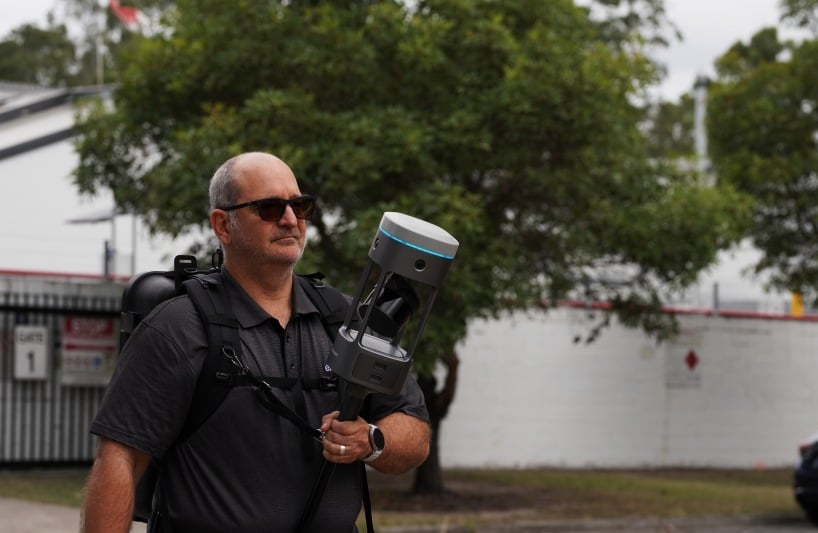
Supported handheld
With the quick mount accessory and backpack frame, access maximum maneuverability for confined areas and any projects or environments handheld scanning is preferred.
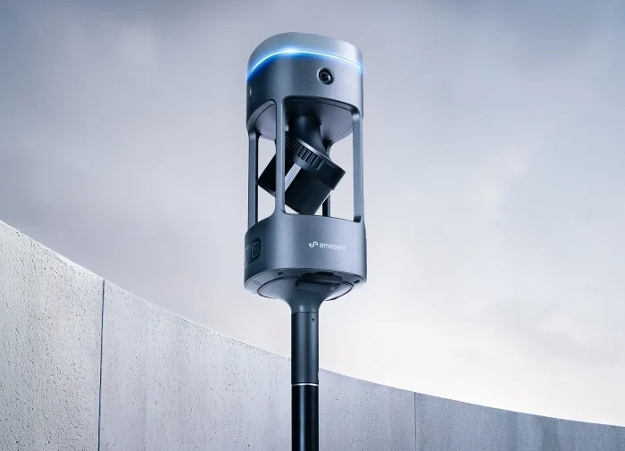
Survey pole*
GX1 mounts on any industry standard survey pole, providing extended reach and ergonomic control for elevated features and overhead capture. Reduces fatigue during extended scanning sessions while maintaining stability and precision.
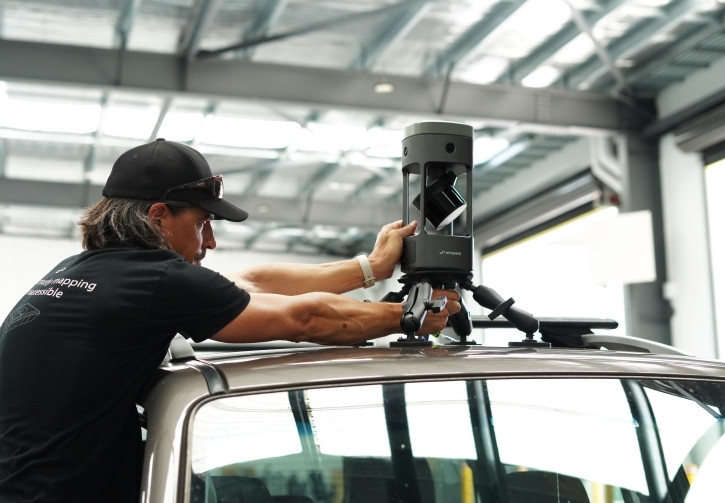
Vehicle mount**
Cover vast areas at vehicle speed for large-scale projects like roadways, infrastructure corridors, and expansive sites. Transform hours of walking into minutes of driving without sacrificing data quality.
* Use your own or purchase through your usual supplier. Does not come with the GX1 kit.
**Available to purchase separately.
See Emesent GX1 in action
Emesent Clients
Key Technical Specifications
- 5-10mm global accuracy
- 5mm local accuracy
- 15mm RTK/PPK accuracy
- IP65 rating
- Wide operating temp range (-10°C to 45°C)
Frequently Asked Questions
Survey firms told us they needed mobile mapping that delivers validated accuracy without compromising speed. GX1 combines up to 5mm global accuracy with the efficiency of mobile capture, eliminating the traditional trade-off between accuracy and productivity.
Emesent GX1 is built for survey professionals who need to deliver high-accuracy deliverables faster - from construction and infrastructure surveyors to engineering firms capturing complex built environments at scale.
Emesent GX1 and Hovermap serve different survey needs. GX1 is purpose-built for ground-based applications requiring maximum accuracy, while Hovermap STX excels in aerial and autonomous drone workflows where versatility across platforms is essential.
Emesent GX1 mounts on a backpack, vehicles, survey pole and supported handheld, with quick-release mounting mechanisms for seamless transitions between platforms during fieldwork.
No, Emesent GX1 is optimized for ground-based mobile mapping. For drone-based surveying, Hovermap STX provides the aerial capabilities and autonomous flight features required for UAV applications.
Yes, Emesent GX1 integrates with Commander for mission planning, Aura for processing, and Aura Cloud for sharing and visualization. It also exports to industry-standard software including Autodesk, Trimble, Bentley, and Leica platforms.
The GX1 kit includes the scanner, 3 x batteries, battery charger, quick-mount device, backpack mount which doubles as the carry case, and all cables needed for immediate deployment in the field.
Users can utilise their own survey pole, or purchase any industry standard survey pole for use with GX1.
The vehicle mount is also available to purchase separately, and users will need to supply their own sim card.