Fully Autonomous Stope Mapping and Rapid Visualization
Eliminate uncertainty to optimize mine planning and production
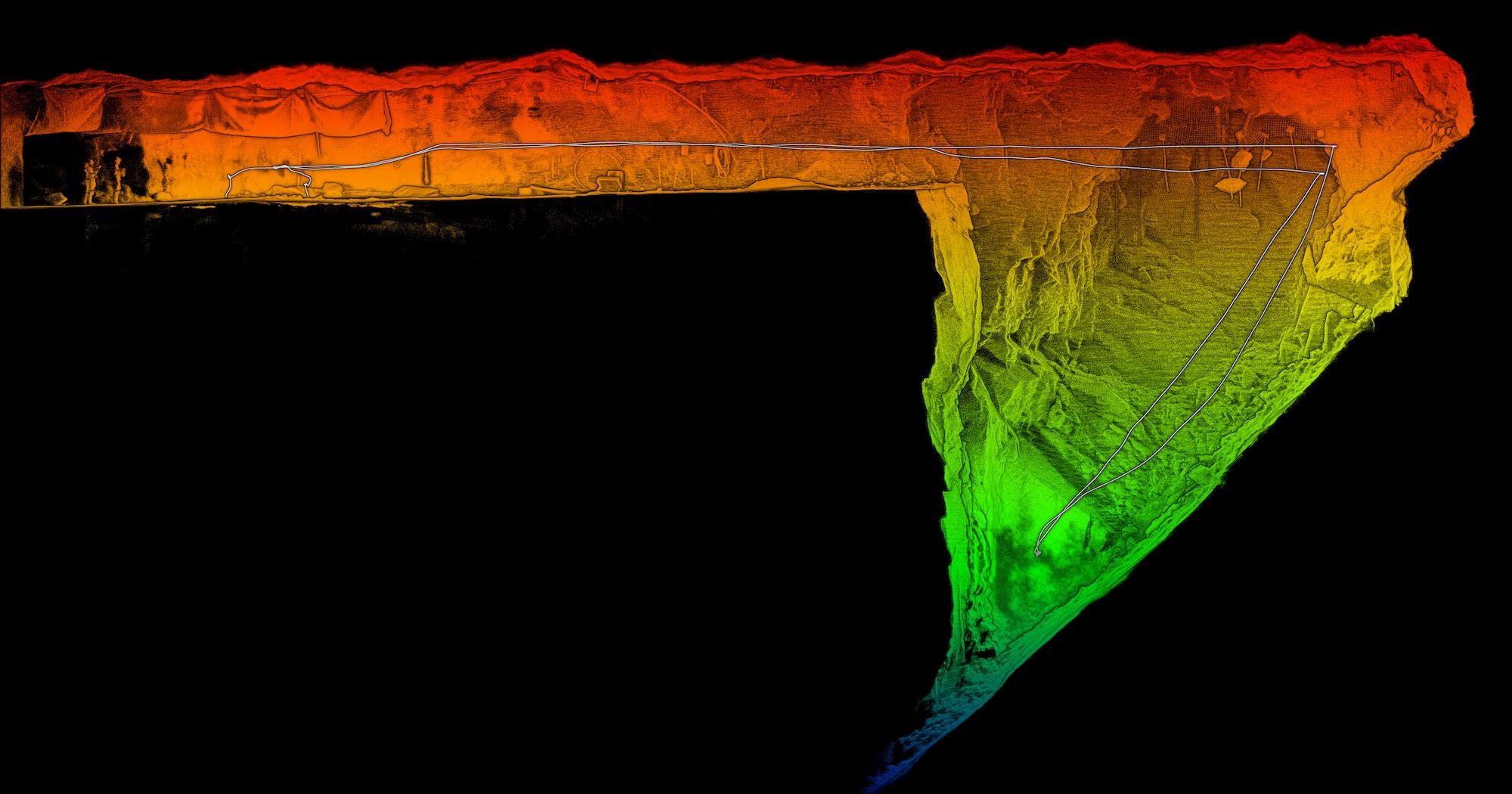
Map hard to access underground excavations – efficiently and accurately
Accurate stope geometry and volume assessments are critical for optimizing production and ensuring structural integrity in underground mining. However, limited access, safety risks, and data collection challenges often stand in the way.
Emesent’s Stope Reconciliation solutions overcome these obstacles with safe, accurate and fully autonomous data capture, delivering complete insights into inaccessible voids. Operators can verify design conformity, assess ore dilution, and improve blasting efficiency—maximizing profitability while keeping personnel and equipment safe.
The challenges faced
A Cavity Monitoring System (CMS) is a common tool for assessing underground voids, but its bulky equipment, manual handling, and significant setup and scan time pose challenges. More critically, personnel must remain close to the stope opening, exposing them to risk. Plus, the requirement for stationary scanning can lead to shadowing, leaving gaps in the data.
Drones offer a safer and more comprehensive alternative—provided the stope opening is wide enough. However, many drone-based solutions face limitations BVLOS (Beyond Visual Line of Sight) and require additional communications infrastructure, restricting capabilities. In the worst case, a loss of communication could mean losing the drone entirely.
The Emesent Solution
Emesent’s stope reconciliation solutions allow geotechnical engineers and surveyors to efficiently and accurately map hard to access underground excavations to ensure compliance to design — quickly and safely, whilst minimizing impact to production. Hovermap’s unmatched versatility sets it apart, while offering multiple deployment options that maximize ROI from a single device.
Drone mounted capture
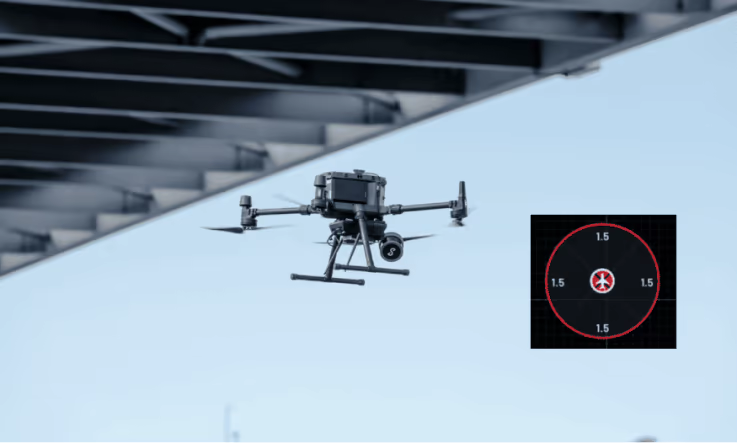
Hovermap’s fully autonomous navigation integrated with next-generation drone platforms delivers fast, reliable data capture in the most challenging environments— without the need for GPS.
Powered by Emesent Cortex, featuring AI powered autonomy, Hovermap enables autonomous flight beyond visual line of sight and communications range, making it ideal for mapping hard-to-reach or previously inaccessible areas. Whether you’re dealing with tight spaces, heavy dust, or high humidity, Hovermap’s industry-leading SLAM technology ensures accurate, confident mapping every time.
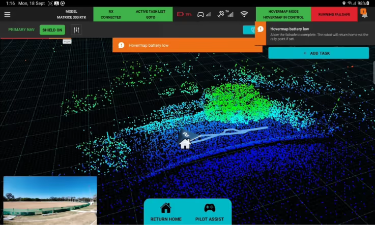
Entire missions—from takeoff to landing—can be executed using just a tablet, keeping operators at a safe distance. Live point cloud streaming via the Commander app provides real-time visibility, while onboard processing delivers instant insights, as well as optimizing the data for rapid network transfer and ease of manipulation with third-party analysis tools.
Hovermap also offers three flexible operating modes, so you can tailor the level of autonomy to your needs—from Pilot Assist, which blends human control with automated safeguards, to fully autonomous missions for maximum efficiency.
LHD mounted capture
See further with Hovermap LHD. Easily mounted to an LHD via a purpose built mount, Hovermap transmits data to the surface via the site network. This enables operators to remotely scan the working face and visualize results in near real time, providing context and enabling analysis while keeping personnel safe. With a 300-meter range and 360° field of view, Hovermap delivers a complete map of the stope, even in total darkness. Operators can identify loose rock, structural hazards, and rill angles in minutes. Its plug-and-play design means crews can perform accurate stope scans anytime, day or night, without the need for significant training.
Hovermap LHD puts an advanced 3D analysis tool in the hands of operators so they can make faster, better decisions as they go, while allowing safe and efficient LHD operation from the surface and removing personnel from potential harm. It can also be deployed on any other equipment or vehicle.
CMS boom mounted capture
Capture more detailed, accurate 3D data in less than half the time of traditional CMS in hard-to-access underground voids not suitable for a drone, such as very small openings. Attached to a CMS boom or pole, Hovermap captures a highly detailed and dense point cloud of a stope in just 1-2 minutes – allowing more accurate volume calculations and geotech structure mapping that improves mine engineering processes.
Unlike traditional CMS, which requires stationary operation, Hovermap can be moved during scanning, providing better coverage per scan with minimal shadowing.
Faster data acquisition
Longer flight time, extended range and greater field of view allows faster data acquisition over larger areas, improving efficiency, especially for large stopes and larger scale projects
Confident decision-making
Eliminate guesswork with data capture of previously inaccessible areas and accurate, high density point clouds to confidently reconcile stope volumes
Full autonomy
With proven reliability in the most challenging environments, Emesent’s world leading SLAM delivers advanced autonomous navigation and collision avoidance without the need for GPS
Improved efficiency
Automated georeferencing saves time and improves accuracy by eliminating manual and error prone processes
Greater ROI
When more than a single scanning technique is needed, the versatility of Hovermap allows multi-platform deployment throughout the mine – drone, vehicle, handheld, backpack, pole – providing greater ROI from a single device
Safer operations
Autonomous and remote data collection keeps personnel from harm, while providing reliable, detailed data capture in hazardous environments
Operational workflow

- Deploy Hovermap on a drone, LHD or CMS.
- Process and automatically georeference your dataset in Aura.
- Easily export into 3rd party tools – Deskwik, Maptek, or Micromine – to compare the result with the design, determine overbreak/underbreak, or estimate dilution and ore losses using block models.
“A boom scan could never provide us with the data that Hovermap is able to collect during our monthly reconciliation scanning program. Having the correct visualization makes a huge difference to volumes and with Hovermap you get amazing volume straight off the bat.
Our geologists were very pleased with the data we sent through to them.”
Martin Le Grange
Barrick Survey Manager, Bulyanhulu
Rapid capture of detailed geotechnical data to optimize mine design
Fast, safe 3D data capture, whilst minimizing impact to production

Full autonomy
Delivers advanced navigation that enables deployment beyond communications range and BVLOS with no additional infrastructure required, with or without GPS

World-leading SLAM
Proven reliability in challenging environments where other SLAM systems fail

Real time visualization
Preview the point cloud as you scan to ensure complete data capture

Automated georeferencing
Improves accuracy and eliminates labor-intensive and time-consuming processes

Advanced collision avoidance
Provides a virtual safety bubble, allowing the drone to fly safely in complex GPS-denied environments

Built in fail-safes
A tiered warning and notification system keeps you informed of any necessary action required during your scan to keep the mission on track

Return to home
The drone will return to home if communication is lost.

Dust filtering
Safer, more confident flying even in heavy dust environments

Versatile deployment
Single device is easily switched between multiple deployment platforms
Applications
-
Shape, volume, dimensions
-
Blast performance
-
Overbreak and underbreak
-
Backfill height volume
-
Brow deformation
-
Access falls of ground
-
Exploration of old workings
Mapping the Carrapateena mega cave
When a 5m diameter hole appeared at the surface of one of the largest copper reserves in the world, regular scanning became critical in order to ensure both the safety of personnel and the stability of mine operations.
Learn how Emesent Hovermap conquered the inaccessible.
Frequently Asked Questions
Hovermap can be deployed in multiple ways to capture accurate data for volume calculations, geological assessments, and stope reconciliation.
From fully autonomous exploration with simple, set-and-forget drone deployment, near real-time visibility mounted on an LHD, or attached to a CMS boom, Hovermap provides high-resolution 3D models within minutes, even in the most challenging environments.
Unlike traditional methods, Hovermap can operate beyond visual line-of-sight and adapt to complex stope geometries, ensuring comprehensive coverage with uniform point density and minimal shadowing.
The data supports production tonne reconciliation, over/under-break analysis, and depletion modeling. Geologists can confidently assess stope grades, verify correct stockpiling, and, in collaboration with metallurgy teams, ensure target grade blending – reducing variability in end-of-month (EOM) reconciliation.
Hovermap significantly enhances the safety of stope mapping in underground mining by enabling remote, drone-based LiDAR scanning.
Traditionally, stope mapping requires personnel to enter recently blasted or unstable areas, exposing them to hazards such as rock falls, poor air quality, and ground instability. Hovermap eliminates this risk by allowing drones to autonomously navigate and map these areas without the need for GPS, thanks to its SLAM (Simultaneous Localization and Mapping) technology. This capability allows for the rapid collection of high-resolution 3D data from complex or hard-to-reach stopes, reducing the time workers spend in potentially dangerous environments.
The detailed scans not only improve the accuracy of stope volume calculations and geotechnical assessments but also help detect hazards such as loose rock or voids, allowing engineers to make better-informed decisions from a safe distance. Additionally, the data can be analyzed and shared remotely, minimizing the number of personnel required on-site and further enhancing operational safety.
Hovermap’s autonomy capabilities have been designed for intuitive operation without the need to be an expert drone pilot or surveyor. This makes advanced exploration accessible to the whole team.
Simply set the area you want to scan, initiate and go – Hovermap takes control of the entire flight without the need for human interaction
Operational efficiency is also greatly improved, as autonomous systems streamline data acquisition and eliminate delays associated with manual methods. This, in turn, boosts productivity by reducing disruptions to production and accelerating the identification of remaining stope volumes, which supports more effective stope planning and equipment utilization. Furthermore, the increased frequency and coverage of scans, even in previously inaccessible areas, enhance decision-making by providing timely and comprehensive data for analysis.
Autonomy supports remote operations by reducing dependence on specialized labor, addressing skill shortages, and lowering operating costs. It also contributes to environmental sustainability by enabling more precise ore targeting, which reduces waste and energy consumption while supporting ESG performance goals.
Finally, autonomous systems deliver consistent, repeatable data collection, which is essential for reliable analytics and long-term planning.


