Make better decisions, faster

    Improve strategic and tactical decision-making and minimize operational risk.

    Emesent Hovermap’s detailed 3D data capture allows the safe and accurate visualization of an environment in minutes. Translate and share actionable insights to aid response planning, assessment and monitoring of evolving situations.

    Use Hovermap for

    • Reduced risk to personnel

      Capture high resolution point cloud data with a drone mounted Hovermap, keeping personnel out of hazardous or dangerous areas.

    • Accelerated insight

      A 360º representation of a scene or environment captured and visualized in minutes to accelerate analysis and improve risk assessment.

    • Enhanced visualization

      Accurate, detailed 3D model that supports quantifiable decision making and delivers increased understanding of the operational environment in evolving scenarios.

    • Improved collaboration and coordination

      Easily visualize and share contextual data with stakeholders and in multi-agency scenarios to improve coordination and mutual understanding.

    • Multiple on-scene deployment options

      The flexibility to deploy the one device in multiple ways depending on on-scene requirements – attached to a drone, robot, vehicle or pole, or as a handheld scanner.

    • An accurate, unbiased system of record

      Record dimensions, evidence and features for analysis and as a documented record of proof.

    Capture and visualize data to improve safety outcomes

    • Operational Planning and Rehearsals

      Reduce risk using accurate 3D models to develop plans and train responders. 3D decision-making and planning for a 3D environment. Provide animated walkthroughs to increase awareness.

    • Site Exploitation and Forensics

      Digitally capture a 360° scene in minutes to generate a highly accurate and detailed 3D forensic model, or “digital twin” for visualization and analysis. Hovermap requires no ambient light to capture data.

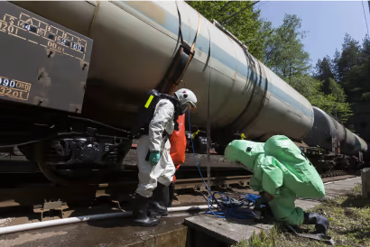
    • CBRNe / HAZMAT Incident Management

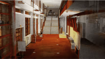
      Enhance mission planning with floor plans and 3D models. Increase situational awareness with georeferenced data. Understand the environment with visual cues for areas not scanned or purposefully hidden.
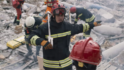
    • Search and Rescue

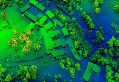
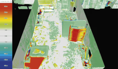
      Highlight changes in the environment down to 5mm. Scan an area above a canopy and easily strip away trees and foliage to see what’s on the ground. Scan and measure complex hazardous ground without putting people in harm’s way.

    • Bomb Response / EOD

      Build a quick 3D picture of the scene and achieve a better perspective for mission planning. Change detection provides easy visual awareness of where evidence is post blast or disruption.

    • Active Assailant

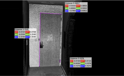
      Build a reference library of annotated 3D models of buildings able to show lines of sight and distances. Easily share these 3D models and animations for response planning and multi-agency collaboration without any software requirements.

    Explore real-life Hovermap applications

    Testimonial

    “Hovermap’s 3D LiDAR technology can be incorporated into 7 of the 12-step CBRN crime scene process: approaching the scene, securing and protecting the scene, the reconnaissance survey; photographing the scene; scene diagram; searching; and the final survey.”

    Christina M. Baxter, Ph.D.
    Emergency Response TIPS, LLC

    Why use Hovermap?

    • Explore beyond line of sight

      When mounted to a drone, Hovermap’s Tap-to-Fly autonomy feature enables mapping in previously inaccessible areas beyond line of sight and communication range. The omnidirectional Collision Avoidance, Guided Exploration, and smart Return-to-Home functions ensure your Hovermap keeps a safe distance from assets and returns home safely with the valuable data it has collected.


    • Built for harsh conditions

      The tough, weather sealed, IP65 rated unit is dust and water resistant, allowing you to map in severe environments. It can operate in temperatures from -10 to 45°C (14 to 113 °F) as well as high humidity, making it ideal for use in underground mines and other harsh environments.


    • Unique versatlility

      The plug and play design and quick-release mechanism allow easy switching between modes. Use Hovermap as a handheld scanner; attached to a drone, vehicle, or pole; lowered in a cage; or mounted to a backpack to easily collect data anywhere. The compact, lightweight design makes it easy to carry and provides longer flight time.

      Explore places to use Hovermap

    • Automated GCP workflow

      Georeferencing in underground mines uses standard prisms and spigots that require specialized mounting adaptors. Emesent has developed mining specific GCP’s and GCP adaptors that meet these specialised requirements. GCP’s are automatically detected during scanning, improving accuracy and eliminating the need for manual georeferencing of the point cloud post processing.


    • Improved decision making

      Mining decision-making is improved with autonomous data capture for volumetrics, over/under break, deformation monitoring, and geotechnical stability monitoring.

      Hovermap’s versatility provides autonomous mapping in challenging, inaccessible areas, while the rotating LiDAR provides an omnidirectional field of view, ensuring 3D data is collected in all directions for complete, shadowless point clouds.


    • Reliable data

      With a combination of world leading LiDAR mapping and drone autonomy, Hovermap produces reliable, accurate data which integrates seamlessly with existing workflows to enable new analytical insights.


    Get in touch with our team of experts