Skip to content
Emesent
  • ProductsExpand
    • Payloads
      • Hovermap
      Software
      • Aura
      • Commander
      • Cortex
      Accessories
      • 360° Image Kit
      • Backpack RTK
      • CMS Mount
      • Drone RTK
      • Hovermap LHD
      • Vehicle
 RTK
      Extensions
      • 360° Colorization
      • Automated Ground 
Control
      • Long Range Radio
      Robotics platforms
      • Boston Dynamics Spot robot
      • DJI M350 drone
      • Freefly Astro Max drone
      Ready to see how Emesent products work?​
      Get in touch
  • SolutionsExpand
    • Mining
      • Convergence Monitoring
      • Open Pit Mine Mapping
      • Stockpile Measurement
      • Stope Reconciliation
      • Underground Mine Production
      AEC
      • Construction As-built Survey
      • Infrastructure As-built Survey
      • Routine Bridge Inspection
      • Topographic Survey
      Industry use cases
      • AEC
      • Geospatial
      • Mining
      • Oil and Gas
      • Public Safety
      Third-party software workflows
      • For AEC
      • For Mining
      Ready to see how Emesent products work?​
      Get in touch
      Mining
      • Convergence Monitoring
      • Underground Mine Production
      AEC
      • Construction As-built Survey
      • Topographic Survey
      Industry use cases
      • AEC
      • Geospatial
      • Mining
      • Oil and Gas
      • Public Safety
      Ready to see how Emesent products work?​
      Get in touch
      Featured Case Study

      Leveraging 3D data for decision-making in public safety

      Read more
  • ResourcesExpand
      • ALL Resources
      • Blog
      • Case studies
      • Datasets
      • Events
      • News
      • Videos
      • Webinars
      • Customer portal
      • Knowledge base
      • Partner portal
      • Client experience
      Ready to see how Emesent products work?​
      Get in touch
      Featured Content

      Hovermap Accuracy Report

      Read more

  • AboutExpand
      • Our team
      • Careers
      • Contact
      Emesent’s strengths
      • Mapping
      • Autonomy
      • Versatility
      Ready to see how Emesent products work?​
      Get in touch
  • BuyExpand
      • Book a demo
      • Resellers
      • Business plans
      • Request Pricing
      Offers
      • Hovermap 100 offer
      • Autonomy discount
      Ready to see how Emesent products work?​
      Get in touch
Customer Portal
Partner Portal
Account
Book a Demo

Emesent
Customer Portal
Partner Portal

Author: Katie Koss

AI-Powered Autonomous Exploration
Videos

AI-Powered Autonomous Exploration

ByKatie Koss May 23, 2025May 23, 2025

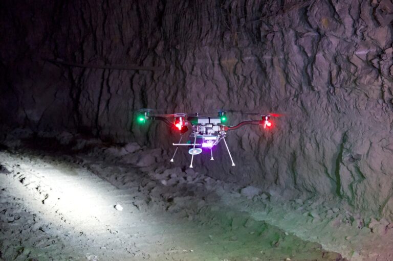
Hear from CTO and Co-founder Farid Kendoul, as he shares Emesent’s fully autonomous exploration. As simple as drawing a bounding box and pressing go. Emesent’s latest solution keeps people out of harm’s way.

Read More AI-Powered Autonomous ExplorationContinue

Maximizing Mining Efficiency: Emesent Hovermap LiDAR Success Stories in Open-Pit and Underground Mining
Webinars

Maximizing Mining Efficiency: Emesent Hovermap LiDAR Success Stories in Open-Pit and Underground Mining

ByKatie Koss May 21, 2025May 22, 2025

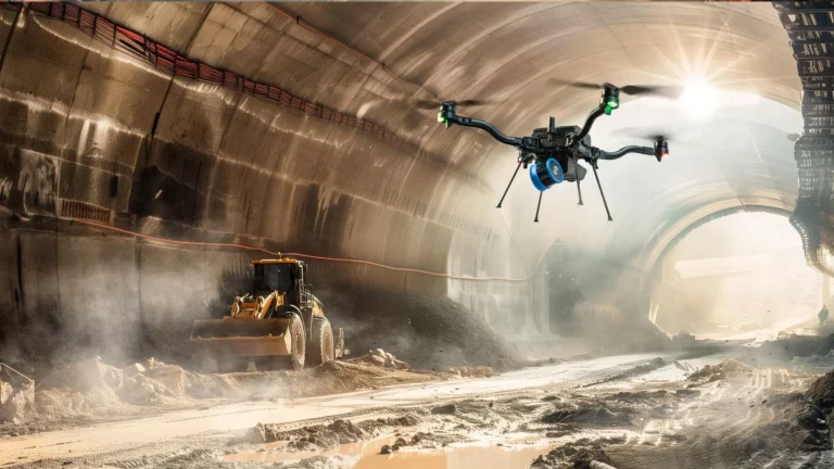
Join us and partner qAIRa for a closer look at how Emesent Hovermap is transforming 3D data capture in modern open-pit and underground mining operations.

Read More Maximizing Mining Efficiency: Emesent Hovermap LiDAR Success Stories in Open-Pit and Underground MiningContinue

Emesent Hovermap Accessories
Brochures

Emesent Hovermap Accessories

ByKatie Koss May 15, 2025May 15, 2025

From backpacks to vehicle mounts, GoPro kits to long range radio…. Learn how Emesent Hovermap can adapt to virtually any mapping scenario.

Read More Emesent Hovermap AccessoriesContinue

Meet Matthew Toohey – Technical Enablement Specialist
Blog

Meet Matthew Toohey – Technical Enablement Specialist

ByKatie Koss May 6, 2025May 6, 2025

Get to know Matthew Toohey, Emesent’s Technical Enablement Specialist, in this Q&A.

Read More Meet Matthew Toohey – Technical Enablement SpecialistContinue

How to capture a stope using autonomous exploration
Videos

How to capture a stope using autonomous exploration

ByKatie Koss May 2, 2025May 2, 2025

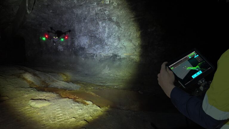
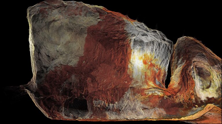
Watch as we demonstrate how to capture a stope using Emesent’s autonomous exploration feature. Learn more at https://emesent.com/solution/stope-reconciliation/

Read More How to capture a stope using autonomous explorationContinue

3 ways to transform stope mapping with Emesent Hovermap
Brochures | Case Studies

3 ways to transform stope mapping with Emesent Hovermap

ByKatie Koss May 1, 2025May 1, 2025

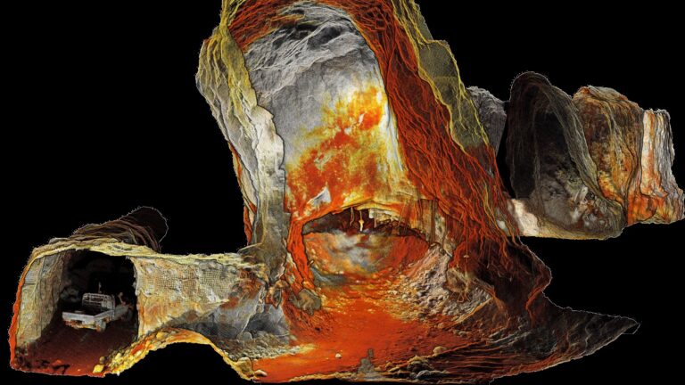
Learn how Emesent Hovermap delivers safer, simpler, smarter stope reconciliation, design, and optimization compared to traditional methods.

Read More 3 ways to transform stope mapping with Emesent HovermapContinue

Emesent enables fully autonomous exploration and mapping of GPS-denied environments
News

Emesent enables fully autonomous exploration and mapping of GPS-denied environments

ByKatie Koss April 29, 2025April 29, 2025

Global digital mapping leader Emesent announces the most significant upgrade yet of its autonomous mapping technology.

Read More Emesent enables fully autonomous exploration and mapping of GPS-denied environmentsContinue

Enhancing the Hovermap Repair Experience: What Clients Can Expect 
Blog

Enhancing the Hovermap Repair Experience: What Clients Can Expect 

ByKatie Koss April 10, 2025April 28, 2025

We caught up with Scott McInnes (Director of Client Experience) and Devang Patel (Director of Manufacturing) to learn more about the latest improvements to the Hovermap repair process.

Read More Enhancing the Hovermap Repair Experience: What Clients Can Expect Continue

Meet Karla Gullon – Customer Support Team Lead
Blog

Meet Karla Gullon – Customer Support Team Lead

ByKatie Koss April 2, 2025April 28, 2025

Get to know Karla Gullon, Emesent’s Customer Support Team Lead, in this Q&A.

Read More Meet Karla Gullon – Customer Support Team LeadContinue

Hovermap ST-X: Use Cases and Workflow for Road Surveys and Marine Applications
Webinars

Hovermap ST-X: Use Cases and Workflow for Road Surveys and Marine Applications

ByKatie Koss March 31, 2025May 23, 2025

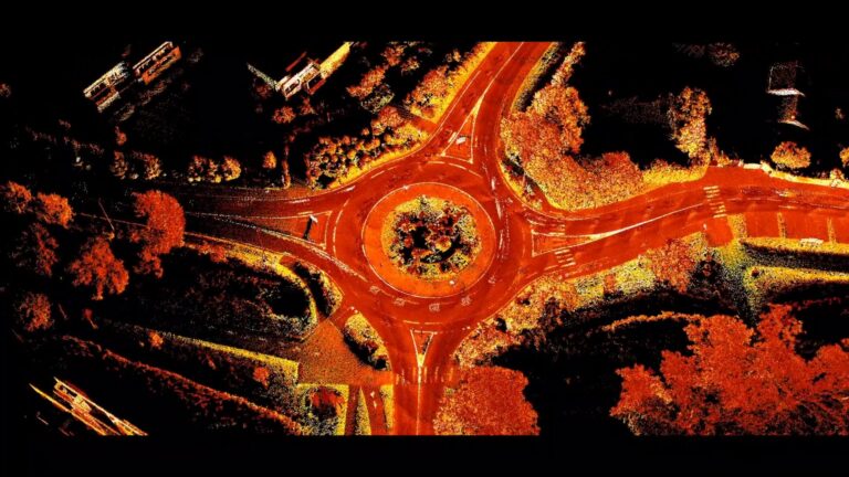
In this practical webinar, Emesent partner EscaDrone share their expertise in using Hovermap ST-X for road survey project. Learn about the benefits and understand the workflow for surveyors in the field.

Read More Hovermap ST-X: Use Cases and Workflow for Road Surveys and Marine ApplicationsContinue

Page navigation

1 2 3 … 8 Next PageNext
Emesent delivers high quality data capture to provide revolutionary efficiency, safety, and operational insights.
About our products
  • Hovermap
  • Aura
  • Commander
  • Book a Demo
  • Request Pricing
  • Business Plans
About our technology
  • Mapping
  • Autonomy
  • Versatility
Info & Resources
  • News & client stories
  • Customer Portal
  • Where to buy
  • Partner Portal
  • Partner with us
About our business
  • Contact us
  • About Emesent
  • Careers
  • Privacy Policy
  • Quality Policy

Copyright © 2025 Emesent. All rights reserved.

  • Products
    • Payloads
      • Hovermap
      Software
      • Aura
      • Commander
      • Cortex
      Accessories
      • 360° Image Kit
      • Backpack RTK
      • CMS Mount
      • Drone RTK
      • Hovermap LHD
      • Vehicle
 RTK
      Extensions
      • 360° Colorization
      • Automated Ground 
Control
      • Long Range Radio
      Robotics platforms
      • Boston Dynamics Spot robot
      • DJI M350 drone
      • Freefly Astro Max drone
      Ready to see how Emesent products work?​
      Get in touch
  • Solutions
    • Mining
      • Convergence Monitoring
      • Open Pit Mine Mapping
      • Stockpile Measurement
      • Stope Reconciliation
      • Underground Mine Production
      AEC
      • Construction As-built Survey
      • Infrastructure As-built Survey
      • Routine Bridge Inspection
      • Topographic Survey
      Industry use cases
      • AEC
      • Geospatial
      • Mining
      • Oil and Gas
      • Public Safety
      Third-party software workflows
      • For AEC
      • For Mining
      Ready to see how Emesent products work?​
      Get in touch
      Mining
      • Convergence Monitoring
      • Underground Mine Production
      AEC
      • Construction As-built Survey
      • Topographic Survey
      Industry use cases
      • AEC
      • Geospatial
      • Mining
      • Oil and Gas
      • Public Safety
      Ready to see how Emesent products work?​
      Get in touch
      Featured Case Study

      Leveraging 3D data for decision-making in public safety

      Read more
  • Resources
      • ALL Resources
      • Blog
      • Case studies
      • Datasets
      • Events
      • News
      • Videos
      • Webinars
      • Customer portal
      • Knowledge base
      • Partner portal
      • Client experience
      Ready to see how Emesent products work?​
      Get in touch
      Featured Content

      Hovermap Accuracy Report

      Read more

  • About
      • Our team
      • Careers
      • Contact
      Emesent’s strengths
      • Mapping
      • Autonomy
      • Versatility
      Ready to see how Emesent products work?​
      Get in touch
  • Buy
      • Book a demo
      • Resellers
      • Business plans
      • Request Pricing
      Offers
      • Hovermap 100 offer
      • Autonomy discount
      Ready to see how Emesent products work?​
      Get in touch
  • Customer Portal
  • Partner Portal

  • Español
  • 日本語
  • 中文 (简体)

Book a Demo
Search