-
Underground Mine Production
See further and understand more in minutes to reduce hazards and improve safety.
-
Bring near real-time visibility to LHD Operations
An inability to adequately identify obstacles and structural hazards prior to and during Load Haul Dump or LHD (also known as scooptram or bogger) operation can lead to accidents and incidents that have significant safety, production loss and cost impacts.
Developed in partnership with Mining Plus, Hovermap’s LHD solution makes underground mine production faster and safer by bringing near real time visibility to LHD operations.
LHD incidents are all too common – with significant consequences
LHDs are vital to the efficiency and productivity of underground mining operations, providing material handling for ore extraction, development work and backfilling, as well as road maintenance. However, accidents relating to LHD use are all too common.
Blind spots, poor lighting and limited visibility offered by 2D cameras, from the cab itself or when operated remotely, result in an inability to identify obstacles and structural hazards – prior to and during LHD operation. 3D scans require specialized surveying skills & equipment, and limited data capture opportunities and extensive processing time mean decisions can take days.
The safety, productivity and cost impacts can be considerable. Loose rocks on side walls, loose mesh or fall of ground where the equipment is operating can have significant consequences for both personnel and equipment. Repeated operation over the same area can create ruts that immobilize the LHD. Stuck or lost equipment costs tens of thousands of dollars for every hour of lost production, or millions of dollars a year, plus recovery costs. There can be a long wait for replacement equipment, adding to the impact. If equipment is recoverable, production loss in that ore area can cause blending problems, or a temporary shutdown for recovery.
As well, an inability to accurately calculate blasted volumes prior to the next shift makes it challenging to optimize LHD requirements, and potentially results in resources not being sent to the area where they are most needed.
-
The Emesent Solution
Hovermap’s LHD solution makes underground mine production faster and safer by bringing near real time visibility to LHD operations. Empowering operators with an advanced 3D analysis tool, the solution enables them to make faster, better decisions as they go, as well as allowing safe and efficient LHD operations from the surface while removing personnel from potential harm.
Connecting easily and securely to the LHD via a purpose built mount, Hovermap enables an operator to remotely conduct a 360 degree scan of the working face and visualize results in near real time for analysis, allowing them to safely identify obstacles and complex structural issues before they become a problem.
The Hovermap LHD solution also provides an efficient means to accurately identify remaining volumes, allowing production supervisors to better plan equipment relocation prior to each shift, optimizing LHD resources to maximize production.
Once attached to the LHD and connected to the network, Hovermap can scan the area in minutes while the equipment is being moved and transmit the data to the remote operator on the surface via onboard wifi, for a full visualization in minutes for analysis. This allows issues to be pre-emptively addressed prior to any impacts, reducing any risk to production. Hovermap also integrates into advanced network operations, including Sandvik Automine.
-
Minimize blind spots
Fast, safe 360 degree visualization of a stope without the blind spots, no light required.
-
Safer operations
Conduct a Hovermap scan and view outputs remotely, without putting personnel in harm’s way.
-
Near real time 3D visualization
Three-dimensional visualization to identify loose rocks, structural hazards, and rill angles.
-
Reduce downtime
Rapid data capture without the need for a drone or to wait for a surveyor on dayshift – the simple design means a user can create accurate stope scans in minutes, with limited training.
-
Maximize production
Reduce LHD downtime, by avoiding rockfall or similar instability incidents, while benefiting from the ability to identify remaining volumes and plan equipment relocation more efficiently.
-
Cost savings
Minimize LHD repair, replacement or recovery costs.
-
-
Operational workflow
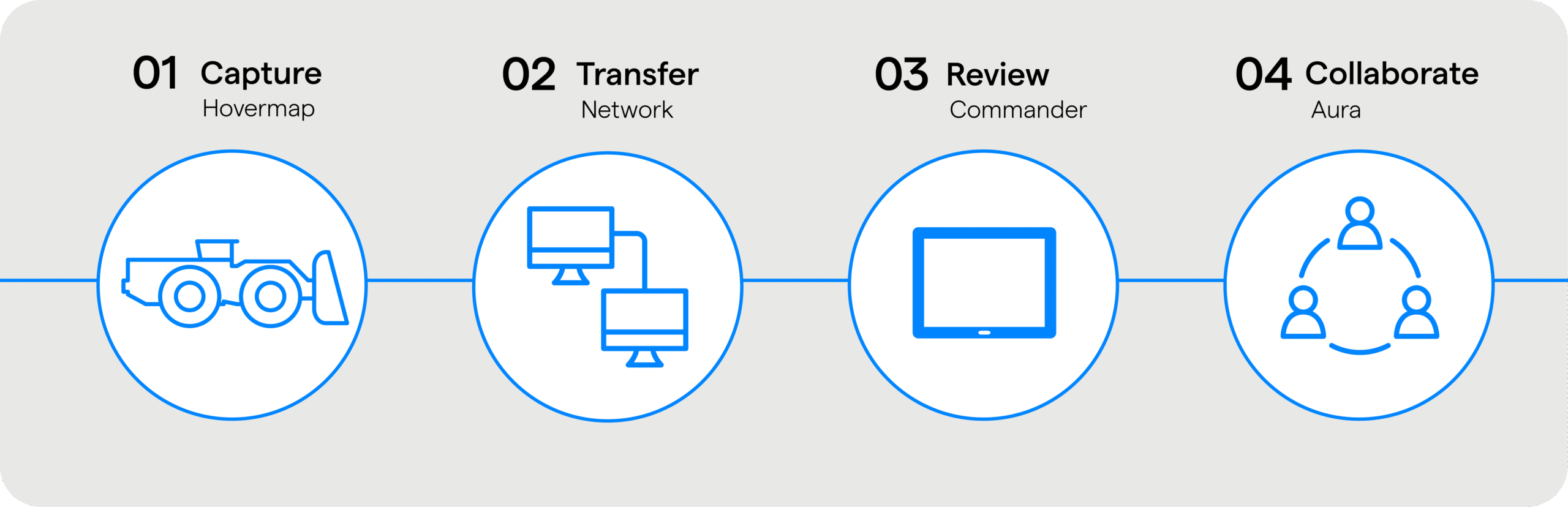
- Deploy Hovermap on an LHD or other vehicle.
- Transfer data to a remote operator over the LHD’s network.
- Review an entire stope scan in minutes.
- Share data with technical teams for further applications.
-
Faster, safer LHD operations
Rapidly identify obstacles and structural hazards to advance safety and improve productivity in LHD operations.
-

Purpose built mount
Complete with magnetic mounting pads and rugged pelican case lets users attach Hovermap to an LHD in minutes
-

View high definition surveys in minutes
Zoom, rotate, pan, and clip using the LHD optimized version of the Commander app
-

Stream as you scan
With a 3D visualization of the environment via the Commander app as you scan
-

High definition 3D visualization
Enabling easier identification and analysis of hazards
-

Extended range
Up to 300m range and 360 degree field of view gives operators a complete map of the stope, even in the dark
-
-
Applications
Underground mining is inherently dangerous but as mine operations have gone deeper, and geomechanical conditions therefore become more extreme, hazards are ever increasing. Emesent’s LHD solution gives 360 degree visibility in minutes to identify:
-
Case study
Advancing Safety and Productivity in LHD Operations: Byrnecut Global shows what is possible
Whilst essential to underground mining, Load-Haul-Dump (LHD) machines are generally operated in hazardous, low-visibility conditions, which not only impacts productivity, but increases risk.
Recognizing the potential for enhanced safety, productivity, and cost savings, leading specialized underground mining contractor Byrnecut Global partnered with Emesent to implement an optimized bogging workflow using Hovermap LHD.
-
Want to see more?
Enquire Now