Accelerate road topographic surveys with Emesent’s versatile RTK solutions
In topographic surveying, capturing a large-scale open area can be extremely time consuming, made harder still because the data needs to be georeferenced and it’s inefficient to lay ground control points. It’s manual and it’s painful. Traditional survey techniques such as terrestrial laser scanners and total stations are highly accurate, but they are extremely slow. Road closures can cost tens of thousands of dollars per day.
While SLAM-based mobile laser scanning solutions offer faster data capture, they too typically struggle with large open areas but for a different reason. SLAM or Simultaneous Localization and Mapping solutions need to understand exactly where they are in the real world in order to create an accurate map. This enables them to create a highly accurate point cloud because they know exactly where they are and where the laser is going. But often large open areas are repetitive or sparse environments where there are limited features for a SLAM solution to grab onto to identify where it is. This causes the SLAM algorithm to “drift”, making the resulting point cloud less accurate and not reflective of reality.
RTK is the answer
RTK, or real time kinematics solves this problem, which is why Hovermap is RTK enabled for drone, vehicle and backpack scans. This integration delivers a simplified, fast tracked workflow that automates the creation of accurate, georeferenced point clouds when scanning large or limited feature areas or challenging environments where ground control targets are not feasible.
For vehicle scans, Hovermap integrates RTK via a simple mount that attaches to any vehicle via magnetic or vacuum feet. The versatility of Hovermap means the possibilities are only limited by the user’s imagination. We also provide an optional kit that allows users to further secure the unit by strapping it down if required.
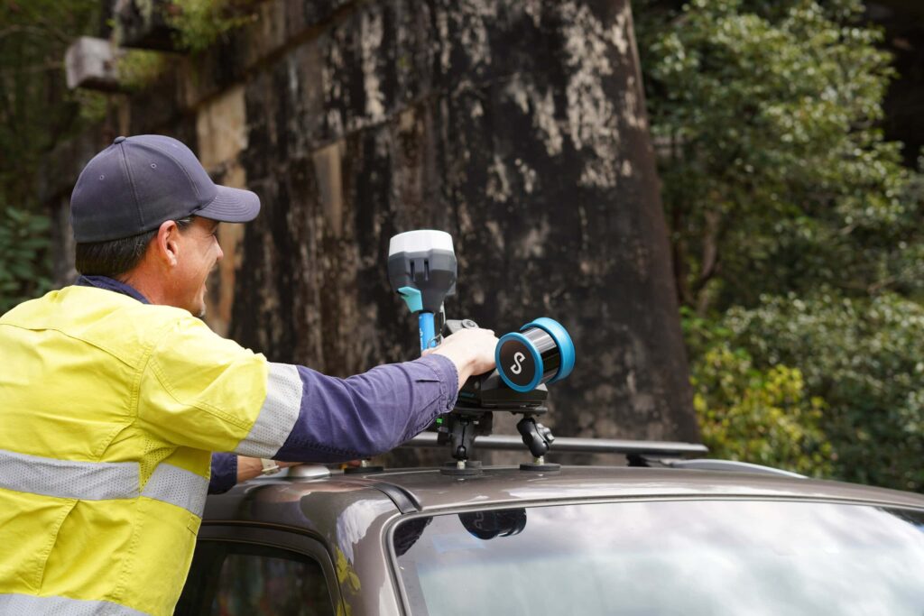
Hovermap currently supports Trimble R10/R12 and R12i and Emlid RS2/RS2+/RS3 GNSS receivers and we will be continuing to expand on this to ensure that users can get georeferencing wherever they are in the world. Alternatively, if there is a base receiver on site you can also connect to your local base station.
A focus on user experience
We know from users in the field that it’s really important to understand that they are capturing data that’s going to deliver the outputs and insights they need. So we’ve put a lot of effort into user experience, including enabling RTK quality to be monitored in real time. This gives an understanding of the approximate georeferencing accuracy that can be expected in post processing, and gives users the confidence they’ll get the results they require.
But it’s not just about the point cloud, it’s about what you can do with it. Hovermap data can be combined with other sources to give further context or understanding of what’s happening on the ground. A GoPro Max attachment allows users to simultaneously capture a 360 degree image of the environment and use the same scan to colorize the point cloud if color is required, helping users:
- Generate panoramic image walk-throughs of the environment
- Get further context when drawing up the point cloud into Revit
- Deliver a polished, aesthetic product to their clients
Processing features unlock further value such as the ability to remove blue sky bleed which is often picked up when using 360 cameras, and to filter out moving objects, giving you cleaner, crisper results out of the box.
We’ve also focused on making Hovermap effortless and easy to use, from installing the system to collecting data, so users can achieve great outputs regardless of technical ability.
Optimized results
Another advantage is that Hovermap will automatically switch between RTK and SLAM to ensure the most reliable and robust point cloud. For example, tall buildings or bridges may interfere with satellite visibility during a city scan which in turn impacts the quality of RTK accuracy. To overcome this, during processing Emesent Aura will dynamically select either RTK or SLAM reference data depending on which has the best position quality to deliver the highest quality results. Aura will choose RTK when corrections are favorable, and will automatically switch to SLAM when they are not.
Proven accuracy
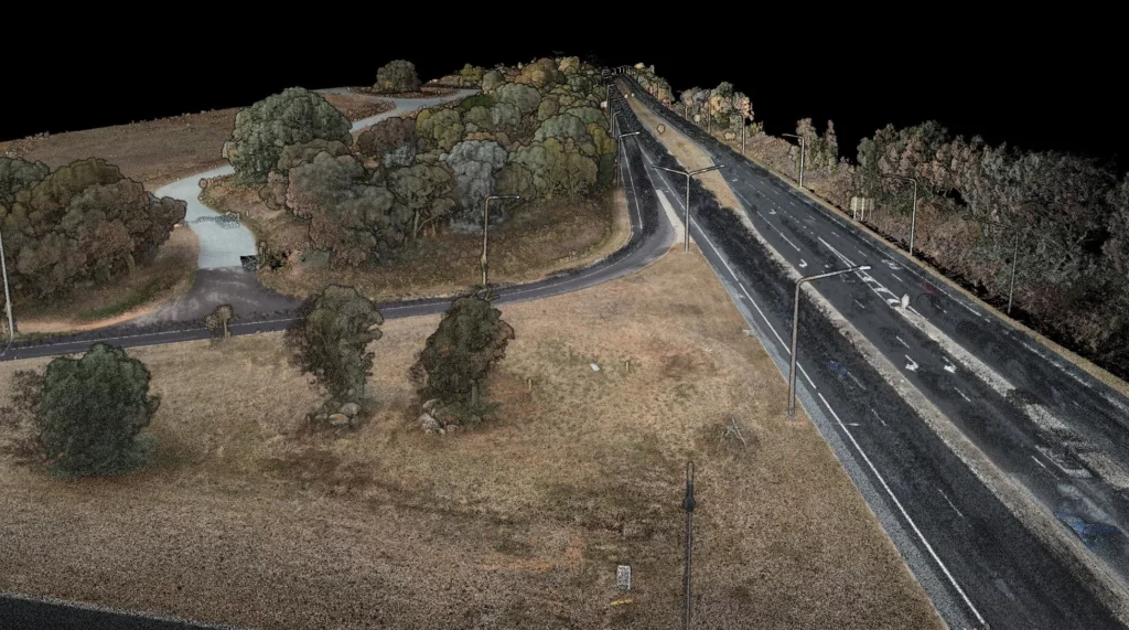
We partnered with independent surveyor, Orion Spatial Solutions, to understand Vehicle RTK accuracy by capturing data along a 2 kilometer stretch of road. The RTK corrections were set up with a local base station with a 1 kilometer baseline. No ground control points were used in the processing of the dataset.
The solution achieved a horizontal RMSE of 30mm and vertical RMSE of 16mm. The table below shows the accuracy achieved against control points at the 68th and 95th percentiles.
| Horizontal Accuracy (XY) | Vertical Accuracy (Z) | |
|---|---|---|
| 68% of points | 0.031m | 0.018m |
| 95% of points | 0.051m | 0.026m |
Choosing the right tool for the job
We know many clients have multiple tools in their toolkit and they’ll pick the right tool for the job. Survey provider Geotwin in Australia is one such example. For a large area topographic and tree survey, dense vegetation meant that drone photogrammetry alone would not deliver the results they required. So to cover the areas unsuitable for drone photogrammetry they used Hovermap on the backpack, and used Hovermap with RTK for vehicle mounted and handheld scanning. To create the final output they combined the scans together.
The flexibility of Hovermap gave Geotwin the ability to choose to drive an area if they couldn’t fly it, or walk an area if they couldn’t drive it – and to make that decision on the spot depending on the prevailing conditions on site that day. This provided huge value, making the survey much easier and faster, with data capture completed in one day versus the estimated three weeks it would have taken using a total station or terrestrial laser scanner.