-
Emesent Aura
-


Process and visualize Hovermap point clouds
Emesent Aura allows the processing and visualization of scans in one intuitive platform, streamlining the way Hovermap users process, view, and analyze point clouds for faster insights and improved decision-making.
Aura makes adding visual context to your point cloud easy, with panoramic 360° colorization for handheld, backpack, vehicle and drone capture. Workflows have been streamlined further with the ability to colorize the point cloud and capture 360° images from the same scan. Processing efficiencies eliminate memory constraints, enabling colorizing of larger point clouds on lower spec machines.
The addition of automated moving object filtering removes the hassle of manually removing noise associated with moving objects such as people or vehicles from your scans.
Aura also supports RTK (Real-time Kinematics), automating high-accuracy georeferencing for Hovermap backpack, vehicle, and above-ground drone-based scans. This enables the delivery of fast, accurate and precise above-ground drone scans on demand, without the need to lay out and georeference ground control points. Aura intelligently leverages both RTK and SLAM to optimize results.
Aura software comes bundled with all Hovermaps.
Why use Aura?
-

Streamlined Workflow
Don’t waste time switching between applications to process and view your data. Aura consolidates it all in one platform, with the ability to export to widely-used industry file formats and CAD packages.
-

Powerful Processing
Emesent Aura makes your workflow seamless and hassle-free no matter how large or numerous your datasets, dense your point clouds, or complex your 3D structures. Job queuing allows for set and forget processing of files, and customized profiles provides scan processing with minimal configuration.
-

Rapid, accurate results
Clean your point clouds with automated filtering. Georeference your point cloud with confidence, thanks to Automated Ground Control alignment (optional) and accuracy reports. Easily export high resolution screenshots for faster stakeholder buy-in.
-

Faster time to insight
Process, view, clean, edit, and colorize Hovermap point clouds in a single streamlined application. Take measurements and easily manipulate the point clouds with a range of 3D tools. Automate previously manual and error-prone tasks to improve the quality of analysis and remove the risk of error.
Emesent Products
-
What’s new & improved
-

360° colorization
View scanned features with true-to-life realism and ensure easier interpretation of objects with enhanced point cloud colorization.
-
Change Detection and Convergence Monitoring
Change detection and convergence monitoring (optional module) leverages Emesent’s SLAM algorithm to deliver a faster and easier workflow for identifying changes in underground environments.
-

360° contextual imagery
Gain additional context for Hovermap point cloud scans by adding 360° panoramic photography. The plug-and-play Handheld 360° Image Kit (sold separately) for Hovermap, combined with seamless processing in Aura, enables the easy capture, registration, and export of 360° panoramic images for analysis.
-

RTK support
During processing, Aura automatically evaluates the GPS signal quality and will intelligently choose the optimal combination of RTK and SLAM (either RTK and SLAM, or SLAM if RTK is not of high enough quality), toggling between the two, to provide the user with the most reliable and robust point cloud. RTK vehicle, backpack, and non-georeferenced scans can easily be combined into a single georeferenced dataset.
-

Reprojection and geoid
It’s faster and easier than ever to achieve final outputs for RTK scans with the reprojection feature in Aura that allows users to apply real world coordinates to their point cloud while processing. Choose your target coordinate reference system along with your geoid and Aura does the transformation for you, no need for manual work or 3rd party software. Supports most national coordinate systems worldwide.
-

Automated noise filtering
Aura’s set-and-forget processing visibly improves the output quality of high-density point clouds with automated filtering of noise and stray points and moving objects.
-

Intuitive and responsive interface
Aura’s simple navigation and intuitive workflows make it easy for users of all levels to process, visualize, analyze and export their data.
-

Reliable, high quality processing
Processing powered by the world’s leading SLAM algorithm converts your data into highly detailed, accurate point clouds, with features to improve point cloud accuracy.
-

Save and export your point clouds in stages
Flexibly manage your point clouds in the way that suits you with the capability to save your work as you go, create separate copies for export, easily change file formats or join multiple point clouds into one file.
-
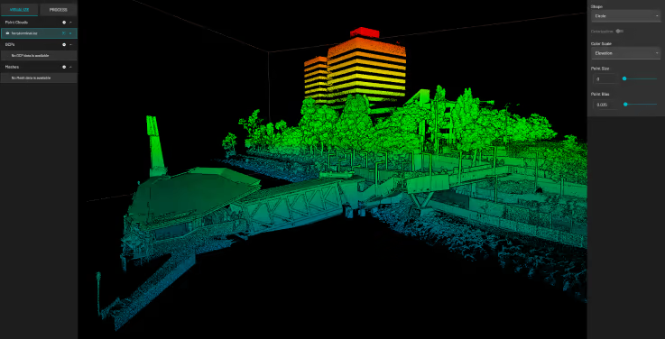
Color Scale Filtering
Uncover hidden details and improve visualization and analysis by applying pre-set filters based on specific attributes, including elevation, position, intensity, time and range.
-
-
Easy, integrated workflow
-

Optimize viewing of Hovermap’s high-density datasets
Aura excels at displaying the dense, detailed point clouds produced by Hovermap, even for extremely large datasets with billions of points.
-

Visualize every detail – even for complex assets
Multi-Frame Rendering efficiently visualizes your point cloud in the highest detail, no matter how dense the points or complex the asset, giving you deeper insights.
-

Process, visualize and analyze simultaneously
Aura gives you the ability to toggle between open point clouds, so you can work on multiple scans at the same time as you are processing, improving efficiencies and saving you time.
-

Reliable, high quality processing
Building on Emesent’s world leading SLAM algorithm, Aura provides even greater detail and more accurate point clouds, delivering superior results for challenging environments.
-
-
Add-on modules
-

Automated Ground Control
Aura’s Automated Ground Control enhances the capabilities of SLAM-based mapping. It enables new use cases, including long, large, and feature-poor assets such as roads, stadiums, and tunnels – previously a challenge for SLAM-based mapping.
During processing, Automated Ground Control automatically detects the reflective ground control targets and uses these to both georeference the point cloud and improve accuracy. After running Automated Ground Control, you can validate your target alignment with a GCP Accuracy Report.
Emesent Ground Control targets are required to use Automated Ground Control.
-

Real-time Kinematics
Aura Real-Time Kinematics (RTK) allows you to scan on demand without the need to lay out or georeference ground control targets – accelerating time from scan to insight for your above ground Hovermap drone scans. The simplified, fast tracked workflow automates the creation of accurate, georeferenced point clouds in large or low feature environments or areas where ground control targets are not feasible. Automatic SLAM correction delivers higher quality results for repeat scans over the same area and enables changes to be easily detected.
RTK vehicle, backpack, and non-georeferenced scans can easily be combined into a single georeferenced dataset – accelerating results for large area scans.
-

360-degree Colorization
Provide additional context to your point clouds with 360-degree colorization, no matter if your data is captured by drone, vehicle, backpack or handheld scanning.
Simply attach the 360-degree camera to Hovermap with our quick-release mount to rapidly capture colorized scans. Our team has developed a powerful software algorithm to achieve precise calibration and synchronization between the camera and LiDAR sensor, keeping it simple and easy to use while producing incredible results.
-

Handheld 360 Image Kit
Emesent’s Handheld 360 Image Kit adds additional information to Hovermap point cloud visualizations with 360-degree contextual imagery.
The 360-degree camera attaches directly to the Hovermap unit and is designed for operators to comfortably hold in one hand, enabling easy generation of 360-degree images while capturing 3D LiDAR data. Hovermap’s camera mount minimizes obstruction by people or equipment, ensuring a high-quality image output. Pre-built image masking allows an operator to use default masks – or import custom masks – to hide their appearance, helping with privacy. 360-degree images and 3D LiDAR data are captured at the same time, with the location of images registered automatically in relation to the point cloud. By using Emesent’s data processing software Aura, image orientation is selected automatically, ensuring no calibration is required.
-
-
Frequently Asked Questions
-
-
Want to learn more?
