Make better decisions, faster
-
Improve strategic and tactical decision-making and minimize operational risk.
Emesent Hovermap’s detailed 3D data capture allows the safe and accurate visualization of an environment in minutes. Translate and share actionable insights to aid response planning, assessment and monitoring of evolving situations.
-
Use Hovermap for
-
Reduced risk to personnel
Capture high resolution point cloud data with a drone mounted Hovermap, keeping personnel out of hazardous or dangerous areas.
-
Accelerated insight
A 360º representation of a scene or environment captured and visualized in minutes to accelerate analysis and improve risk assessment.
-
Enhanced visualization
Accurate, detailed 3D model that supports quantifiable decision making and delivers increased understanding of the operational environment in evolving scenarios.
-
Improved collaboration and coordination
Easily visualize and share contextual data with stakeholders and in multi-agency scenarios to improve coordination and mutual understanding.
-
Multiple on-scene deployment options
The flexibility to deploy the one device in multiple ways depending on on-scene requirements – attached to a drone, robot, vehicle or pole, or as a handheld scanner.
-
An accurate, unbiased system of record
Record dimensions, evidence and features for analysis and as a documented record of proof.
-
-
Capture and visualize data to improve safety outcomes
-

Operational Planning and Rehearsals
Reduce risk using accurate 3D models to develop plans and train responders. 3D decision-making and planning for a 3D environment. Provide animated walkthroughs to increase awareness.
-

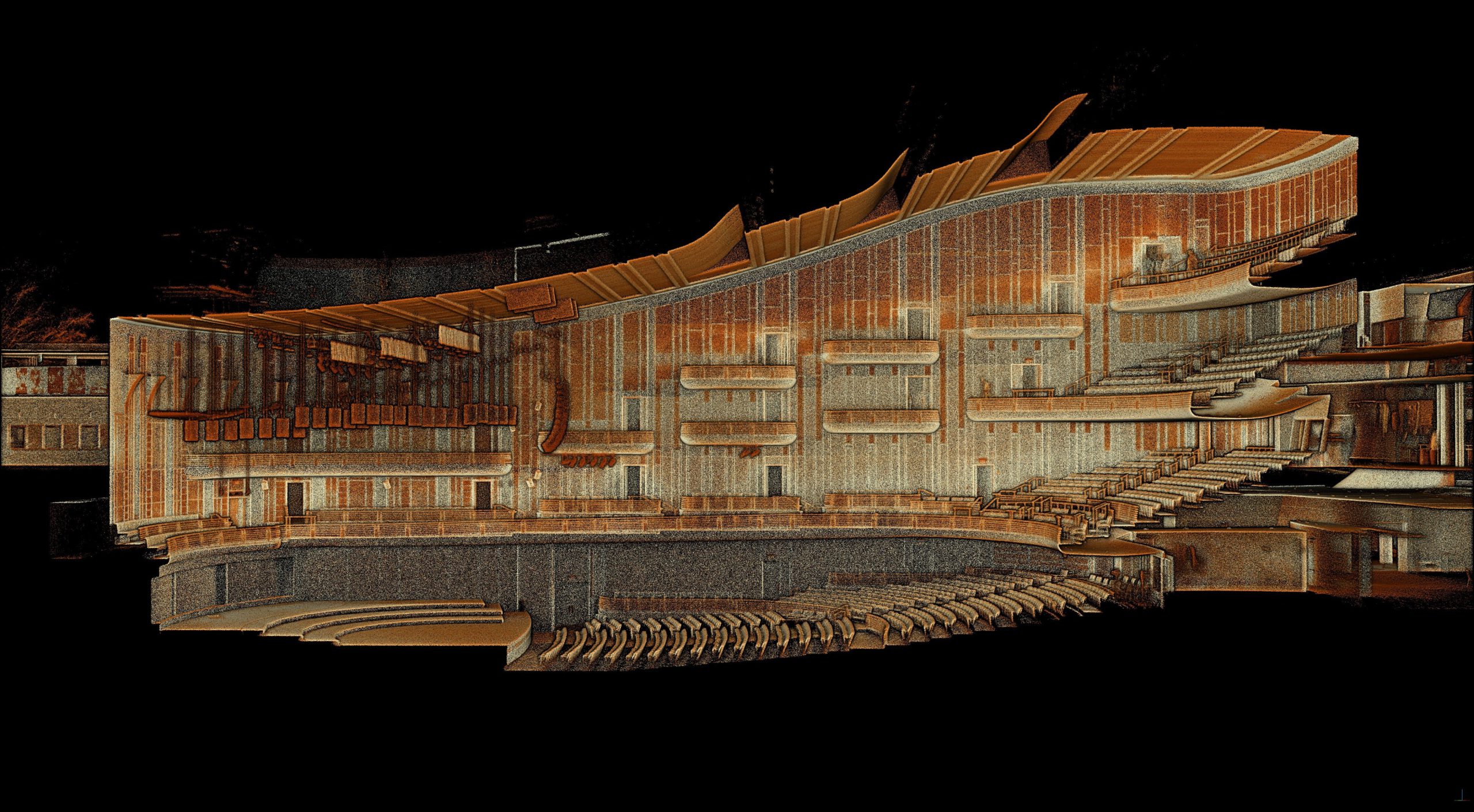
Site Exploitation and Forensics
Digitally capture a 360° scene in minutes to generate a highly accurate and detailed 3D forensic model, or “digital twin” for visualization and analysis. Hovermap requires no ambient light to capture data.
-

CBRNe / HAZMAT Incident Management
Enhance mission planning with floor plans and 3D models. Increase situational awareness with georeferenced data. Understand the environment with visual cues for areas not scanned or purposefully hidden.
-

Search and Rescue
Highlight changes in the environment down to 5mm. Scan an area above a canopy and easily strip away trees and foliage to see what’s on the ground. Scan and measure complex hazardous ground without putting people in harm’s way.
-

Bomb Response / EOD
Build a quick 3D picture of the scene and achieve a better perspective for mission planning. Change detection provides easy visual awareness of where evidence is post blast or disruption.
-

Active Assailant
Build a reference library of annotated 3D models of buildings able to show lines of sight and distances. Easily share these 3D models and animations for response planning and multi-agency collaboration without any software requirements.
-
-
Explore real-life Hovermap applications
-
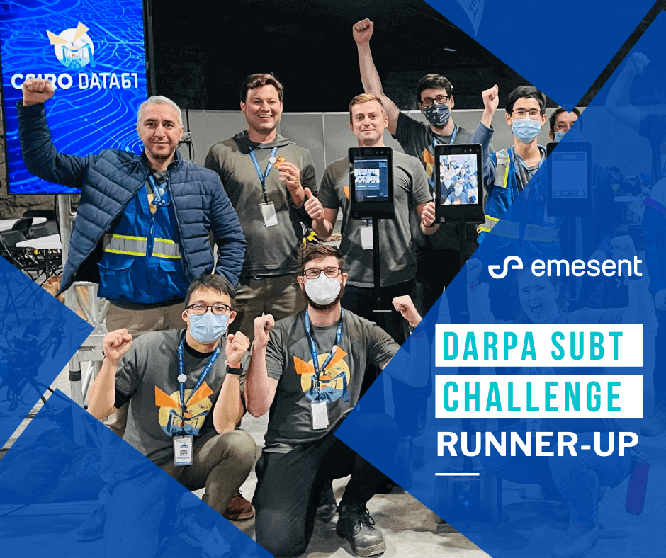
Emesent – CSIRO Data61 – Georgia Tech team Runner-up in DARPA’s SubT Challenge
For four days, elite robotics teams from around the world gathered in Kentucky, USA to compete in the prestigious DARPA Subterranean Challenge, which has been dubbed the ‘Olympics for Robotics’.
-
Augmenting first-responder decision-making with 3D LiDAR data
-
Powerful Decision Support with Data-driven Insights for Defense & First Responders
Mobile mapping over longer distances or in some of the more challenging, featureless environments has been limited by LiDAR capabilities – until now.
-
Improving VIP security planning at the Notre Dame de Fourvière Basilica with 3D modelling
Built in the 1800’s, UNESCO World Heritage listed Notre Dame de Fourvière Basilica welcomes over 2.5 million visitors per year, including VIPs from around the world.

-
-
Testimonial
“Hovermap’s 3D LiDAR technology can be incorporated into 7 of the 12-step CBRN crime scene process: approaching the scene, securing and protecting the scene, the reconnaissance survey; photographing the scene; scene diagram; searching; and the final survey.”
Christina M. Baxter, Ph.D.Emergency Response TIPS, LLC
-
Why use Hovermap?
-

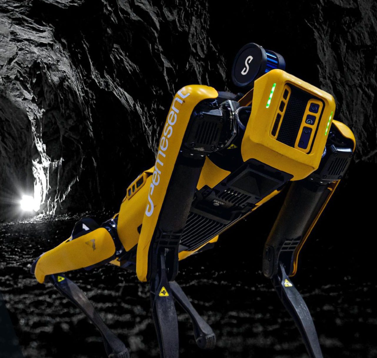
Unique versatility
The plug-and-play design and quick-release mechanism allow easy switching between modes, making it ideal for unknown or evolving scenarios. Deploy Hovermap as a handheld scanner; attached to a drone, vehicle, or pole; lowered in a cage; or mounted to a backpack. The compact, lightweight design makes it easy to carry and provides longer flight time.
-

Sub-centimetre accuracy
Emesent’s Automated Ground Control further increases the accuracy of Hovermap point clouds. It enhances the capabilities of its SLAM-based mapping – improving SLAM accuracy and removing drift or slips to deliver survey grade results.
-

Not reliant on GPS
World-leading SLAM (simultaneous localization and mapping) techniques, with Emesent’s advanced algorithms, extend Hovermap’s capabilities to provide autonomous data capture using a drone or other robotic platform, enabling users to maintain safe distances, situational awareness and accurate mapping even when GPS is not available, such as in tunnels or caves.
-

Easy to train, use and deploy
Hovermaps automated data capture, streamlined workflows and plug and play design allow users to start scanning at the touch of a button.
-

Works in zero light environments
Hovermap can operate in complete darkness without impacting scan quality.
-

Adaptable, contextual data capture
Colorize, animate, overlay information or add annotations to present a comprehensive visual picture to teams on the ground and remote stakeholders. Gain exact measurements to aid assessment, such as distances and widths, as well as volumetrics.
-

Analyze data in multiple ways
Hovermap’s filters enable data to be analyzed in multiple ways including by time, intensity and height to uncover additional insights. Areas with different reflectivity can be highlighted, such as areas of contamination from an oil or chemical spill, that otherwise may not be clearly visible.
-