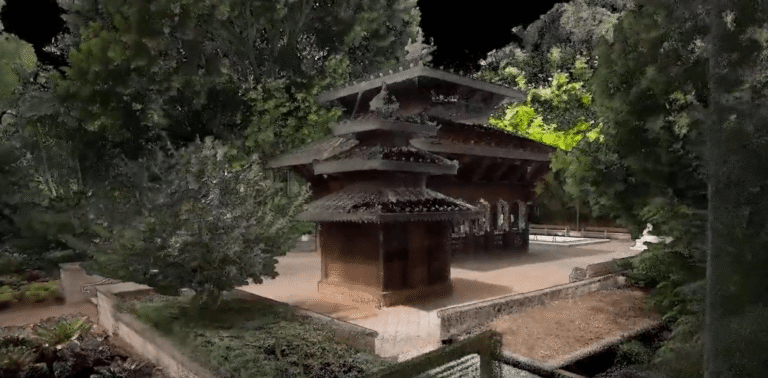
Skip to content
Emesent
  • ProductsExpand
    • Payloads
      • Hovermap
      Software
      • Aura
      • Commander
      • Cortex
      Accessories
      • 360° Image Kit
      • Backpack RTK
      • CMS Mount
      • Drone RTK
      • Hovermap LHD
      • Vehicle
 RTK
      Extensions
      • 360° Colorization
      • Automated Ground 
Control
      • Long Range Radio
      Robotics platforms
      • Boston Dynamics Spot robot
      • DJI M350 drone
      • Freefly Astro Max drone
      Ready to see how Emesent products work?​
      Get in touch
  • SolutionsExpand
    • Mining
      • Convergence Monitoring
      • Open Pit Mine Mapping
      • Stockpile Measurement
      • Stope Reconciliation
      • Underground Mine Production
      AEC
      • Construction As-built Survey
      • Infrastructure As-built Survey
      • Routine Bridge Inspection
      • Topographic Survey
      Industry use cases
      • AEC
      • Geospatial
      • Mining
      • Oil and Gas
      • Public Safety
      Third-party software workflows
      • For AEC
      • For Mining
      Ready to see how Emesent products work?​
      Get in touch
      Mining
      • Convergence Monitoring
      • Underground Mine Production
      AEC
      • Construction As-built Survey
      • Topographic Survey
      Industry use cases
      • AEC
      • Geospatial
      • Mining
      • Oil and Gas
      • Public Safety
      Ready to see how Emesent products work?​
      Get in touch
      Featured Case Study

      Leveraging 3D data for decision-making in public safety

      Read more
  • ResourcesExpand
      • ALL Resources
      • Blog
      • Case studies
      • Datasets
      • Events
      • News
      • Videos
      • Webinars
      • Customer portal
      • Knowledge base
      • Partner portal
      • Client experience
      Ready to see how Emesent products work?​
      Get in touch
      Featured Content

      Hovermap Accuracy Report

      Read more

  • AboutExpand
      • Our team
      • Careers
      • Contact
      Emesent’s strengths
      • Mapping
      • Autonomy
      • Versatility
      Ready to see how Emesent products work?​
      Get in touch
  • BuyExpand
      • Book a demo
      • Resellers
      • Business plans
      • Request Pricing
      Offers
      • Hovermap 100 offer
      • Autonomy discount
      Ready to see how Emesent products work?​
      Get in touch
Customer Portal
Partner Portal
Account
Book a Demo

Emesent
Customer Portal
Partner Portal

Vehicle RTK accuracy study
Datasets

Vehicle RTK accuracy study

ByKatie Koss December 5, 2024January 2, 2025

Download the dataset produced during Emesent’s Vehicle RTK accuracy test. Conducted along a 2km stretch of road in Brisbane, Australia, and verified by Orion Spatial Solutions.

Read More Vehicle RTK accuracy studyContinue

Hovermap accuracy deep-dive
Webinars

Hovermap accuracy deep-dive

ByKatie Koss December 4, 2024December 17, 2024

Join Emesent Co-founder and Chief Strategy Officer Dr Stefan Hrabar, as he does a deep dive into what makes Emesent Hovermap so accurate compared to other SLAM-based scanners.

Read More Hovermap accuracy deep-diveContinue

Best Practice for Automated Ground Control Points
Videos

Best Practice for Automated Ground Control Points

ByKatie Koss December 4, 2024December 4, 2024

See best practice in action as Emesent’s Henry Henderson-Genefaas walks through the capture and processing of real-world data using automated ground control points. With clear step-by-step instructions and some troubleshooting tips, this video answers some of our most frequently asked GCP questions.

Read More Best Practice for Automated Ground Control PointsContinue

Emesent appoints Christofer Catania to board, affirms company focus on mining industry transformation as key pillar to global growth
News

Emesent appoints Christofer Catania to board, affirms company focus on mining industry transformation as key pillar to global growth

ByKatie Koss November 29, 2024

Emesent, developer of autonomous SLAM-based mobile surveying solution Hovermap, has expanded its board, inviting mining industry executive Christofer Catania to join.

Read More Emesent appoints Christofer Catania to board, affirms company focus on mining industry transformation as key pillar to global growthContinue

Hovermap Accuracy Report
Case Studies

Hovermap Accuracy Report

ByKatie Koss November 4, 2024December 17, 2024

In this report, we present the results of an evaluation coordinated by the U.S. Institute of Building Documentation (USIBD) at the GeoWeek 2024 Expo, comparing Emesent’s Hovermap ST-X with other leading LiDAR scanners.

Read More Hovermap Accuracy ReportContinue

Accelerate road topographic surveys with Emesent’s versatile RTK solutions
Blog

Accelerate road topographic surveys with Emesent’s versatile RTK solutions

ByKatie Koss October 24, 2024October 24, 2024

How RTK solves the problem of SLAM ‘drift’ when mapping large open areas such as topographic road surveys.

Read More Accelerate road topographic surveys with Emesent’s versatile RTK solutionsContinue

Saint John’s Anglican Cathedral – Brisbane, Australia
Videos

Saint John’s Anglican Cathedral – Brisbane, Australia

ByKatie Koss October 22, 2024October 22, 2024

This scan of Saint John’s Anglican Cathedral in Brisbane, Australia, shows the high level of detail you can capture using Hovermap ST-X. Emesent’s mapping and colorization quality ensured that the scan could be used for future planning and restorations of the cathedral.

Read More Saint John’s Anglican Cathedral – Brisbane, AustraliaContinue

Solving the challenge of accurate projections: a guide for surveyors and cartographers
Blog

Solving the challenge of accurate projections: a guide for surveyors and cartographers

ByKatie Koss October 22, 2024October 22, 2024

A surveyor’s and cartographer’s guide to ensuring consistent and accurate projections with Emesent Aura’s new reprojection workflow.

Read More Solving the challenge of accurate projections: a guide for surveyors and cartographersContinue

Global georeferencing accuracy with Backpack RTK
Case Studies

Global georeferencing accuracy with Backpack RTK

ByKatie Koss October 18, 2024October 18, 2024

Verified by independent surveyor Orion Spatial Solutions, this September 2024 report tests the georeferencing accuracy of Emesent’s Backpack RTK solution.

Read More Global georeferencing accuracy with Backpack RTKContinue

Uncovering the largest sea cave in the world
Blog

Uncovering the largest sea cave in the world

ByKatie Koss October 18, 2024October 18, 2024

Emesent’s Henry Henderson-Genefaas traveled to the remote Faroe Islands in the North Atlantic, in a bid to uncover the largest sea cave in the world using Hovermap.

Read More Uncovering the largest sea cave in the worldContinue

Page navigation

Previous PagePrevious 1 2 3 4 5 … 27 Next PageNext
Emesent delivers high quality data capture to provide revolutionary efficiency, safety, and operational insights.
About our products
  • Hovermap
  • Aura
  • Commander
  • Book a Demo
  • Request Pricing
  • Business Plans
About our technology
  • Mapping
  • Autonomy
  • Versatility
Info & Resources
  • News & client stories
  • Customer Portal
  • Where to buy
  • Partner Portal
  • Partner with us
About our business
  • Contact us
  • About Emesent
  • Careers
  • Privacy Policy
  • Quality Policy

Copyright © 2025 Emesent. All rights reserved.

  • Products
    • Payloads
      • Hovermap
      Software
      • Aura
      • Commander
      • Cortex
      Accessories
      • 360° Image Kit
      • Backpack RTK
      • CMS Mount
      • Drone RTK
      • Hovermap LHD
      • Vehicle
 RTK
      Extensions
      • 360° Colorization
      • Automated Ground 
Control
      • Long Range Radio
      Robotics platforms
      • Boston Dynamics Spot robot
      • DJI M350 drone
      • Freefly Astro Max drone
      Ready to see how Emesent products work?​
      Get in touch
  • Solutions
    • Mining
      • Convergence Monitoring
      • Open Pit Mine Mapping
      • Stockpile Measurement
      • Stope Reconciliation
      • Underground Mine Production
      AEC
      • Construction As-built Survey
      • Infrastructure As-built Survey
      • Routine Bridge Inspection
      • Topographic Survey
      Industry use cases
      • AEC
      • Geospatial
      • Mining
      • Oil and Gas
      • Public Safety
      Third-party software workflows
      • For AEC
      • For Mining
      Ready to see how Emesent products work?​
      Get in touch
      Mining
      • Convergence Monitoring
      • Underground Mine Production
      AEC
      • Construction As-built Survey
      • Topographic Survey
      Industry use cases
      • AEC
      • Geospatial
      • Mining
      • Oil and Gas
      • Public Safety
      Ready to see how Emesent products work?​
      Get in touch
      Featured Case Study

      Leveraging 3D data for decision-making in public safety

      Read more
  • Resources
      • ALL Resources
      • Blog
      • Case studies
      • Datasets
      • Events
      • News
      • Videos
      • Webinars
      • Customer portal
      • Knowledge base
      • Partner portal
      • Client experience
      Ready to see how Emesent products work?​
      Get in touch
      Featured Content

      Hovermap Accuracy Report

      Read more

  • About
      • Our team
      • Careers
      • Contact
      Emesent’s strengths
      • Mapping
      • Autonomy
      • Versatility
      Ready to see how Emesent products work?​
      Get in touch
  • Buy
      • Book a demo
      • Resellers
      • Business plans
      • Request Pricing
      Offers
      • Hovermap 100 offer
      • Autonomy discount
      Ready to see how Emesent products work?​
      Get in touch
  • Customer Portal
  • Partner Portal

  • Español
  • 日本語
  • 中文 (简体)

Book a Demo
Search