Skip to content
Emesent
  • ProductsExpand
    • Payloads
      • Hovermap
      Software
      • Aura
      • Commander
      • Cortex
      Accessories
      • 360° Image Kit
      • Backpack RTK
      • CMS Mount
      • Drone RTK
      • Hovermap Cage
      • Hovermap LHD
      • Vehicle
 RTK
      Extensions
      • 360° Colorization
      • Automated Ground 
Control
      • Long Range Radio
      Robotics platforms
      • Boston Dynamics Spot robot
      • DJI M350 drone
      • Freefly Astro Max drone
      Ready to see how Emesent products work?​
      Get in touch
  • SolutionsExpand
    • Mining
      • Convergence Monitoring
      • Open Pit Mine Mapping
      • Stockpile Measurement
      • Stope Reconciliation
      • Underground Mine Production
      AEC
      • Construction As-built Survey
      • Infrastructure As-built Survey
      • Routine Bridge Inspection
      • Scan to BIM
      • Topographic Survey
      Industry use cases
      • AEC
      • Defense
      • Geospatial
      • Mining
      • Oil and Gas
      • Public Safety
      Third-party software workflows
      • For AEC
      • For Mining
      Ready to see how Emesent products work?​
      Get in touch
      Mining
      • Convergence Monitoring
      • Underground Mine Production
      AEC
      • Construction As-built Survey
      • Topographic Survey
      Industry use cases
      • AEC
      • Geospatial
      • Mining
      • Oil and Gas
      • Public Safety
      Ready to see how Emesent products work?​
      Get in touch
      Featured Case Study

      Leveraging 3D data for decision-making in public safety

      Read more
  • ResourcesExpand
      • ALL Resources
      • Blog
      • Case studies
      • Datasets
      • Events
      • News
      • Videos
      • Webinars
      • Client Portal
      • Emesent Assure
      • Knowledge Base
      • Partner Portal
      • Client Experience
      Ready to see how Emesent products work?​
      Get in touch
      Featured Content

      Hovermap Accuracy Report

      Read more

  • AboutExpand
      • Our Team
      • Careers
      • Contact
      Emesent’s strengths
      • Mapping
      • Autonomy
      • Versatility
      Ready to see how Emesent products work?​
      Get in touch
  • BuyExpand
      • Book a Demo
      • Explore Business Plans
      • Find a Reseller
      • Refer a Peer
      • Request Pricing
      • Shop Emesent Store
      Offers
      • Hovermap 100 offer
      • Autonomy discount
      Ready to see how Emesent products work?​
      Get in touch
Client Portal
Partner Portal
Account
Talk to a Specialist

Emesent
Customer Portal
Partner Portal

Emesent competes in “Robotics Olympics” Finals
News

Emesent competes in “Robotics Olympics” Finals

ByKatie Koss September 23, 2021October 7, 2024

While most of the world is recuperating from the excitement of the Tokyo Olympics and Paralympics; others have been gearing up for the ‘Robotic Olympics’.

Read More Emesent competes in “Robotics Olympics” FinalsContinue

Emesent and Coptrz  partner to provide local training in the UK
News

Emesent and Coptrz partner to provide local training in the UK

ByKatie Koss September 14, 2021July 9, 2025

Emesent is excited to announce a new partnership with Coptrz, commercial drone experts based in Leeds, United Kingdom.

Read More Emesent and Coptrz partner to provide local training in the UKContinue

EROCK improves data capture in infrastructure and construction
Webinars

EROCK improves data capture in infrastructure and construction

ByKatie Koss September 8, 2021May 8, 2025

Eric Bennett, President and Founder of EROCK LLC, shares how they reduce time on site, keep away from hazards and capture accurate data with Hovermap.

Read More EROCK improves data capture in infrastructure and constructionContinue

Hovermap-Zoe to be unveiled at the Commercial UAV Expo
News

Hovermap-Zoe to be unveiled at the Commercial UAV Expo

ByKatie Koss August 29, 2021July 9, 2025

The Commercial UAV Expo is the place to learn about the most exciting new technologies in UAVs.

Read More Hovermap-Zoe to be unveiled at the Commercial UAV ExpoContinue

Hovermap compatibility expanded to European-made Zoe drone
News

Hovermap compatibility expanded to European-made Zoe drone

ByKatie Koss August 23, 2021October 7, 2024

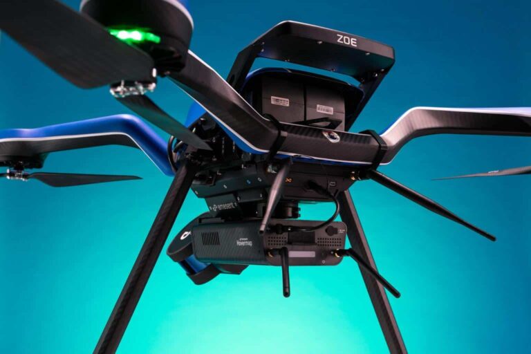
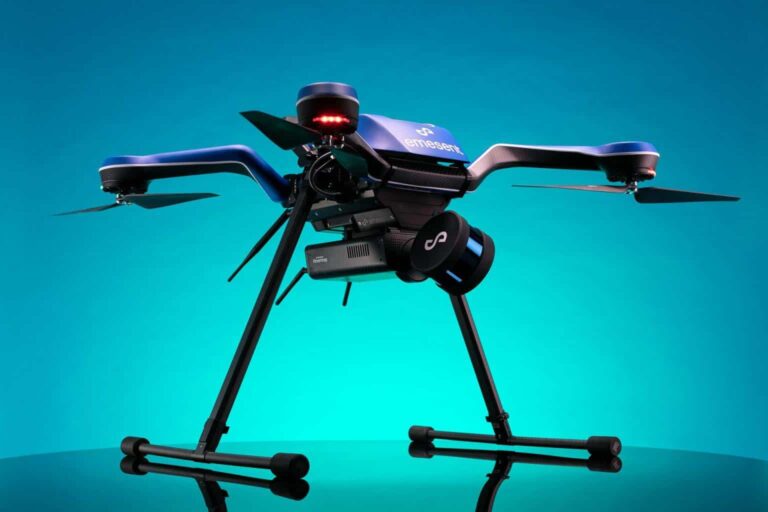
We’re proud to announce that Hovermap, our autonomy, and mapping payload, is now plug-and-play compatible with the Zoe aircraft from Acecore Technologies, made in the Netherlands.

Read More Hovermap compatibility expanded to European-made Zoe droneContinue

Accurate stope volume results with Hovermap
News

Accurate stope volume results with Hovermap

ByKatie Koss August 5, 2021July 9, 2025

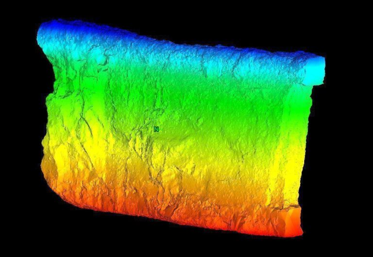
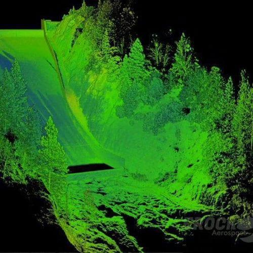
Hovermap was recently introduced into Barrick’s Bulyanhulu narrow-vein gold mine for stope mapping by Emesent partner, Dwyka Mining Services, headquartered in Johannesburg, South Africa.

Read More Accurate stope volume results with HovermapContinue

In House Image achieve considerable savings with Hovermap’s versatility
News

In House Image achieve considerable savings with Hovermap’s versatility

ByKatie Koss August 4, 2021October 7, 2024

Joseph Bellantoni has been working in construction documentation for over twenty years.

Read More In House Image achieve considerable savings with Hovermap’s versatilityContinue

Walden Environmental Engineering and Harkin Aerial Fly Through Part 360 Compliance
News

Walden Environmental Engineering and Harkin Aerial Fly Through Part 360 Compliance

ByKatie Koss July 6, 2021October 15, 2024

As we all try to reduce our lasting impact on the planet, it is becoming more common for municipal Sanitation Departments and private solid waste facilities in New York state to process yard wastes for reuse as mulch, keeping this material from landfill.

Read More Walden Environmental Engineering and Harkin Aerial Fly Through Part 360 ComplianceContinue

Grass Valley Center for the Arts Optimizes Operations with Hovermap
Case Studies

Grass Valley Center for the Arts Optimizes Operations with Hovermap

ByKatie Koss July 6, 2021October 10, 2024

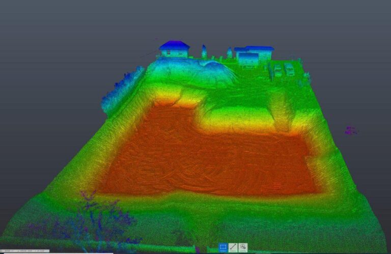
Hovermap provides Grass Valley Center for the Arts great insights after a new renovation and valuable data for future renovations.

Read More Grass Valley Center for the Arts Optimizes Operations with HovermapContinue

20+ Ways to Use Hovermap in Underground Mining
Case Studies

20+ Ways to Use Hovermap in Underground Mining

ByKatie Koss July 5, 2021October 10, 2024

Underground mines see savings on equipment and consultancy services with Hovermap’s versatility providing multiple applications.

Read More 20+ Ways to Use Hovermap in Underground MiningContinue

Page navigation

Previous PagePrevious 1 … 21 22 23 24 25 … 29 Next PageNext
Emesent provides actionable spatial intelligence within challenging and GPS-denied environments.
About our products
  • Hovermap
  • Aura
  • Commander
  • Book a Demo
  • Request Pricing
  • Business Plans
About our technology
  • Mapping
  • Autonomy
  • Versatility
Info & Resources
  • News & client stories
  • Client Portal
  • Where to buy
  • Partner Portal
  • Partner with us
  • Refer a peer
About our business
  • Contact us
  • About Emesent
  • Careers
  • Privacy Policy
  • Quality Policy

Copyright © 2025 Emesent. All rights reserved.

  • Products
    • Payloads
      • Hovermap
      Software
      • Aura
      • Commander
      • Cortex
      Accessories
      • 360° Image Kit
      • Backpack RTK
      • CMS Mount
      • Drone RTK
      • Hovermap Cage
      • Hovermap LHD
      • Vehicle
 RTK
      Extensions
      • 360° Colorization
      • Automated Ground 
Control
      • Long Range Radio
      Robotics platforms
      • Boston Dynamics Spot robot
      • DJI M350 drone
      • Freefly Astro Max drone
      Ready to see how Emesent products work?​
      Get in touch
  • Solutions
    • Mining
      • Convergence Monitoring
      • Open Pit Mine Mapping
      • Stockpile Measurement
      • Stope Reconciliation
      • Underground Mine Production
      AEC
      • Construction As-built Survey
      • Infrastructure As-built Survey
      • Routine Bridge Inspection
      • Scan to BIM
      • Topographic Survey
      Industry use cases
      • AEC
      • Defense
      • Geospatial
      • Mining
      • Oil and Gas
      • Public Safety
      Third-party software workflows
      • For AEC
      • For Mining
      Ready to see how Emesent products work?​
      Get in touch
      Mining
      • Convergence Monitoring
      • Underground Mine Production
      AEC
      • Construction As-built Survey
      • Topographic Survey
      Industry use cases
      • AEC
      • Geospatial
      • Mining
      • Oil and Gas
      • Public Safety
      Ready to see how Emesent products work?​
      Get in touch
      Featured Case Study

      Leveraging 3D data for decision-making in public safety

      Read more
  • Resources
      • ALL Resources
      • Blog
      • Case studies
      • Datasets
      • Events
      • News
      • Videos
      • Webinars
      • Client Portal
      • Emesent Assure
      • Knowledge Base
      • Partner Portal
      • Client Experience
      Ready to see how Emesent products work?​
      Get in touch
      Featured Content

      Hovermap Accuracy Report

      Read more

  • About
      • Our Team
      • Careers
      • Contact
      Emesent’s strengths
      • Mapping
      • Autonomy
      • Versatility
      Ready to see how Emesent products work?​
      Get in touch
  • Buy
      • Book a Demo
      • Explore Business Plans
      • Find a Reseller
      • Refer a Peer
      • Request Pricing
      • Shop Emesent Store
      Offers
      • Hovermap 100 offer
      • Autonomy discount
      Ready to see how Emesent products work?​
      Get in touch
  • Customer Portal
  • Partner Portal

  • العربية‏
  • Español
  • 日本語
  • Português
  • 中文 (简体)

Book a Demo
Search