Skip to content
Emesent
  • ProductsExpand
    • Payloads
      • Hovermap
      Software
      • Aura
      • Commander
      • Cortex
      Accessories
      • 360° Image Kit
      • Backpack RTK
      • CMS Mount
      • Drone RTK
      • Hovermap Cage
      • Hovermap LHD
      • Vehicle
 RTK
      Extensions
      • 360° Colorization
      • Automated Ground 
Control
      • Long Range Radio
      Robotics platforms
      • Boston Dynamics Spot robot
      • DJI M350 drone
      • Freefly Astro Max drone
      Ready to see how Emesent products work?​
      Get in touch
  • SolutionsExpand
    • Mining
      • Convergence Monitoring
      • Open Pit Mine Mapping
      • Stockpile Measurement
      • Stope Reconciliation
      • Underground Mine Production
      AEC
      • Construction As-built Survey
      • Infrastructure As-built Survey
      • Routine Bridge Inspection
      • Scan to BIM
      • Topographic Survey
      Industry use cases
      • AEC
      • Defense
      • Geospatial
      • Mining
      • Oil and Gas
      • Public Safety
      Third-party software workflows
      • For AEC
      • For Mining
      Ready to see how Emesent products work?​
      Get in touch
      Mining
      • Convergence Monitoring
      • Underground Mine Production
      AEC
      • Construction As-built Survey
      • Topographic Survey
      Industry use cases
      • AEC
      • Geospatial
      • Mining
      • Oil and Gas
      • Public Safety
      Ready to see how Emesent products work?​
      Get in touch
      Featured Case Study

      Leveraging 3D data for decision-making in public safety

      Read more
  • ResourcesExpand
      • ALL Resources
      • Blog
      • Case studies
      • Datasets
      • Events
      • News
      • Videos
      • Webinars
      • Client Portal
      • Emesent Assure
      • Knowledge Base
      • Partner Portal
      • Client Experience
      Ready to see how Emesent products work?​
      Get in touch
      Featured Content

      Hovermap Accuracy Report

      Read more

  • AboutExpand
      • Our Team
      • Careers
      • Contact
      Emesent’s strengths
      • Mapping
      • Autonomy
      • Versatility
      Ready to see how Emesent products work?​
      Get in touch
  • BuyExpand
      • Book a Demo
      • Explore Business Plans
      • Find a Reseller
      • Refer a Peer
      • Request Pricing
      • Shop Emesent Store
      Offers
      • Hovermap 100 offer
      • Autonomy discount
      Ready to see how Emesent products work?​
      Get in touch
Client Portal
Partner Portal
Account
Talk to a Specialist

Emesent
Customer Portal
Partner Portal

Engineering & Construction

Emesent’s High-Quality Mapping And Drone Autonomy Technology Enables The Rapid Creation Of 3D Digital Twins
Case Studies

Emesent’s High-Quality Mapping And Drone Autonomy Technology Enables The Rapid Creation Of 3D Digital Twins

ByKatie Koss April 7, 2022October 10, 2024

This report, produced by Verdantix, delves into the features that enable Hovermap to assist in the rapid creation of digital twins

Read More Emesent’s High-Quality Mapping And Drone Autonomy Technology Enables The Rapid Creation Of 3D Digital TwinsContinue

GeoZICHT Achieves Entire Traffic Bridge Inspection
Case Studies

GeoZICHT Achieves Entire Traffic Bridge Inspection

ByKatie Koss April 6, 2022October 10, 2024

GeoZICHT sought a tool to enhance the collection of complete visual inspection data for bridge inspections while also increasing the overall safety of the underlying process.

Read More GeoZICHT Achieves Entire Traffic Bridge InspectionContinue

Brierley Associates Speeds up road tunnel inspection
Case Studies

Brierley Associates Speeds up road tunnel inspection

ByKatie Koss January 11, 2022October 10, 2024

Brierley Associates sought a solution to tunnel inspection that would reduce the disruption to traffic while keeping the inspection team safe.

Read More Brierley Associates Speeds up road tunnel inspectionContinue

Kalmar Municipality streamlines digital capture for community planning
Case Studies

Kalmar Municipality streamlines digital capture for community planning

ByKatie Koss December 17, 2021October 10, 2024

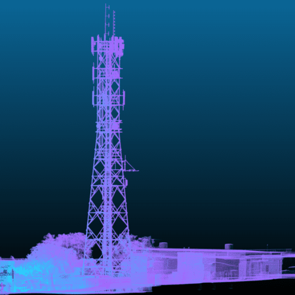
Kalmar Municipality captured a heritage landmark completely and quickly – a great start to their digital capture of the municipality.

Read More Kalmar Municipality streamlines digital capture for community planningContinue

Walden Environmental Engineering Captures New Insights and Revenue
Case Studies

Walden Environmental Engineering Captures New Insights and Revenue

ByKatie Koss December 6, 2021October 10, 2024

Walden Environmental Engineering have realized new revenue opportunities

Read More Walden Environmental Engineering Captures New Insights and RevenueContinue

From Point Clouds to CAD Drawings
Webinars

From Point Clouds to CAD Drawings

ByKatie Koss November 26, 2021August 1, 2025

Producing better outputs, faster with Hovermap data in PointCab Origins

Read More From Point Clouds to CAD DrawingsContinue

Expediting As-built Capture with Versatile LiDAR Scanners
Webinars

Expediting As-built Capture with Versatile LiDAR Scanners

ByKatie Koss November 16, 2021August 1, 2025

Find out how two spatial data experts are reducing the time they spend capturing existing structures and help their clients achieve considerable savings with Hovermap’s versatility

Read More Expediting As-built Capture with Versatile LiDAR ScannersContinue

Hovermap oil and gas drill rig scan
Videos

Hovermap oil and gas drill rig scan

ByKatie Koss October 21, 2021October 10, 2024

Read More Hovermap oil and gas drill rig scanContinue

Mapping the UQ Green Bridge
Videos

Mapping the UQ Green Bridge

ByKatie Koss October 21, 2021October 10, 2024

Read More Mapping the UQ Green BridgeContinue

Interior Scan – Captured in 5 minutes
Videos

Interior Scan – Captured in 5 minutes

ByKatie Koss October 21, 2021October 10, 2024

Read More Interior Scan – Captured in 5 minutesContinue

Page navigation

Previous PagePrevious 1 2 3 4 5 6 Next PageNext
Emesent provides actionable spatial intelligence within challenging and GPS-denied environments.
About our products
  • Hovermap
  • Aura
  • Commander
  • Book a Demo
  • Request Pricing
  • Business Plans
About our technology
  • Mapping
  • Autonomy
  • Versatility
Info & Resources
  • News & client stories
  • Client Portal
  • Where to buy
  • Partner Portal
  • Partner with us
  • Refer a peer
About our business
  • Contact us
  • About Emesent
  • Careers
  • Privacy Policy
  • Quality Policy

Copyright © 2025 Emesent. All rights reserved.

  • Products
    • Payloads
      • Hovermap
      Software
      • Aura
      • Commander
      • Cortex
      Accessories
      • 360° Image Kit
      • Backpack RTK
      • CMS Mount
      • Drone RTK
      • Hovermap Cage
      • Hovermap LHD
      • Vehicle
 RTK
      Extensions
      • 360° Colorization
      • Automated Ground 
Control
      • Long Range Radio
      Robotics platforms
      • Boston Dynamics Spot robot
      • DJI M350 drone
      • Freefly Astro Max drone
      Ready to see how Emesent products work?​
      Get in touch
  • Solutions
    • Mining
      • Convergence Monitoring
      • Open Pit Mine Mapping
      • Stockpile Measurement
      • Stope Reconciliation
      • Underground Mine Production
      AEC
      • Construction As-built Survey
      • Infrastructure As-built Survey
      • Routine Bridge Inspection
      • Scan to BIM
      • Topographic Survey
      Industry use cases
      • AEC
      • Defense
      • Geospatial
      • Mining
      • Oil and Gas
      • Public Safety
      Third-party software workflows
      • For AEC
      • For Mining
      Ready to see how Emesent products work?​
      Get in touch
      Mining
      • Convergence Monitoring
      • Underground Mine Production
      AEC
      • Construction As-built Survey
      • Topographic Survey
      Industry use cases
      • AEC
      • Geospatial
      • Mining
      • Oil and Gas
      • Public Safety
      Ready to see how Emesent products work?​
      Get in touch
      Featured Case Study

      Leveraging 3D data for decision-making in public safety

      Read more
  • Resources
      • ALL Resources
      • Blog
      • Case studies
      • Datasets
      • Events
      • News
      • Videos
      • Webinars
      • Client Portal
      • Emesent Assure
      • Knowledge Base
      • Partner Portal
      • Client Experience
      Ready to see how Emesent products work?​
      Get in touch
      Featured Content

      Hovermap Accuracy Report

      Read more

  • About
      • Our Team
      • Careers
      • Contact
      Emesent’s strengths
      • Mapping
      • Autonomy
      • Versatility
      Ready to see how Emesent products work?​
      Get in touch
  • Buy
      • Book a Demo
      • Explore Business Plans
      • Find a Reseller
      • Refer a Peer
      • Request Pricing
      • Shop Emesent Store
      Offers
      • Hovermap 100 offer
      • Autonomy discount
      Ready to see how Emesent products work?​
      Get in touch
  • Customer Portal
  • Partner Portal

  • العربية‏
  • Español
  • 日本語
  • Português
  • 中文 (简体)

Book a Demo
Search