Skip to content
Emesent
  • ProductsExpand
    • Payloads
      • Hovermap
      Software
      • Aura
      • Commander
      • Cortex
      Accessories
      • 360° Image Kit
      • Backpack RTK
      • CMS Mount
      • Drone RTK
      • Hovermap Cage
      • Hovermap LHD
      • Vehicle
 RTK
      Extensions
      • 360° Colorization
      • Automated Ground 
Control
      • Long Range Radio
      Robotics platforms
      • Boston Dynamics Spot robot
      • DJI M350 drone
      • Freefly Astro Max drone
      Ready to see how Emesent products work?​
      Get in touch
  • SolutionsExpand
    • Mining
      • Convergence Monitoring
      • Open Pit Mine Mapping
      • Stockpile Measurement
      • Stope Reconciliation
      • Underground Mine Production
      AEC
      • Construction As-built Survey
      • Infrastructure As-built Survey
      • Routine Bridge Inspection
      • Scan to BIM
      • Topographic Survey
      Industry use cases
      • AEC
      • Defense
      • Geospatial
      • Mining
      • Oil and Gas
      • Public Safety
      Third-party software workflows
      • For AEC
      • For Mining
      Ready to see how Emesent products work?​
      Get in touch
      Mining
      • Convergence Monitoring
      • Underground Mine Production
      AEC
      • Construction As-built Survey
      • Topographic Survey
      Industry use cases
      • AEC
      • Geospatial
      • Mining
      • Oil and Gas
      • Public Safety
      Ready to see how Emesent products work?​
      Get in touch
      Featured Case Study

      Leveraging 3D data for decision-making in public safety

      Read more
  • ResourcesExpand
      • ALL Resources
      • Blog
      • Case studies
      • Datasets
      • Events
      • News
      • Videos
      • Webinars
      • Client Portal
      • Emesent Assure
      • Knowledge Base
      • Partner Portal
      • Client Experience
      Ready to see how Emesent products work?​
      Get in touch
      Featured Content

      Hovermap Accuracy Report

      Read more

  • AboutExpand
      • Our Team
      • Careers
      • Contact
      Emesent’s strengths
      • Mapping
      • Autonomy
      • Versatility
      Ready to see how Emesent products work?​
      Get in touch
  • BuyExpand
      • Book a Demo
      • Explore Business Plans
      • Find a Reseller
      • Refer a Peer
      • Request Pricing
      • Shop Emesent Store
      Offers
      • Hovermap 100 offer
      • Autonomy discount
      Ready to see how Emesent products work?​
      Get in touch
Client Portal
Partner Portal
Account
Talk to a Specialist

Emesent
Customer Portal
Partner Portal

Author: Katie Koss

Hovermap Wins Geo Week’s LiDAR Leader Outstanding Innovation Award
News

Hovermap Wins Geo Week’s LiDAR Leader Outstanding Innovation Award

ByKatie Koss February 8, 2022July 9, 2025

Emesent is proud to have their Hovermap LiDAR mapping and autonomy payload announced as the winner of the Geo Week LiDAR Leader Award for Outstanding Innovation.

Read More Hovermap Wins Geo Week’s LiDAR Leader Outstanding Innovation AwardContinue

Digitalization of Cultural Heritage
Webinars

Digitalization of Cultural Heritage

ByKatie Koss February 3, 2022May 8, 2025

Listen to this recorded webinar to hear from some of the team using 3D reality capture in support of digital archeology to study and preserve the Quinkan rock art sites.

Read More Digitalization of Cultural HeritageContinue

Truckee River Flume – LiDAR vs Photogrammetry
Videos

Truckee River Flume – LiDAR vs Photogrammetry

ByKatie Koss February 2, 2022October 10, 2024

Read More Truckee River Flume – LiDAR vs PhotogrammetryContinue

DARPA Pushing Emesent Further Into Unreachable Places
News

DARPA Pushing Emesent Further Into Unreachable Places

ByKatie Koss January 28, 2022October 7, 2024

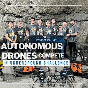
Considered the Olympics of Robotics, the DARPA SubTerranean Challenge is an autonomous robotics competition developed by the US Defence Advanced Research Project Agency (DARPA).

Read More DARPA Pushing Emesent Further Into Unreachable PlacesContinue

Emesent and Robotic Skies partner to provide local servicing for clients in the Americas
News

Emesent and Robotic Skies partner to provide local servicing for clients in the Americas

ByKatie Koss January 25, 2022July 9, 2025

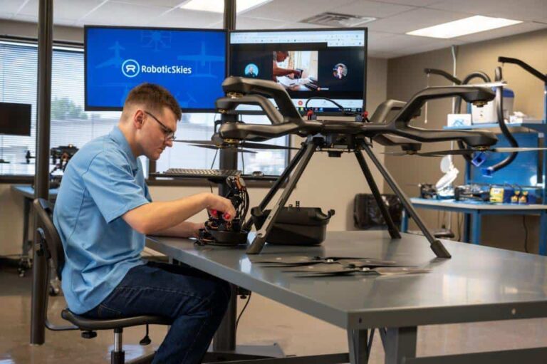
Emesent is pleased to announce a new service partnership with Robotic Skies that will mean users in the Americas get their Emesent products serviced and repaired locally.

Read More Emesent and Robotic Skies partner to provide local servicing for clients in the AmericasContinue

DARPA Competition Drives Autonomous Exploration
Webinars

DARPA Competition Drives Autonomous Exploration

ByKatie Koss January 19, 2022October 7, 2024

Watch this webinar to learn how placing second in the DARPA SubTerranean Challenge allowed Emesent to advance their technology’s autonomous capabilities in exploration and mapping in underground environments.

Read More DARPA Competition Drives Autonomous ExplorationContinue

Spillway Structure Captured After 60 Years
News

Spillway Structure Captured After 60 Years

ByKatie Koss January 17, 2022October 7, 2024

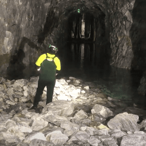
Since construction, the overflow tunnel hadn’t been accessed or inspected until AMKVO arrived with Hovermap.

Read More Spillway Structure Captured After 60 YearsContinue

Brierley Associates Speeds up road tunnel inspection
Case Studies

Brierley Associates Speeds up road tunnel inspection

ByKatie Koss January 11, 2022October 10, 2024

Brierley Associates sought a solution to tunnel inspection that would reduce the disruption to traffic while keeping the inspection team safe.

Read More Brierley Associates Speeds up road tunnel inspectionContinue

UDM Group Improves Efficiency and Safety for Topographic Surveys
Case Studies

UDM Group Improves Efficiency and Safety for Topographic Surveys

ByKatie Koss December 22, 2021October 10, 2024

Hovermap helps UDM Group reduce time-on-site for a bridge survey and flood study.

Read More UDM Group Improves Efficiency and Safety for Topographic SurveysContinue

Kalmar Municipality streamlines digital capture for community planning
Case Studies

Kalmar Municipality streamlines digital capture for community planning

ByKatie Koss December 17, 2021October 10, 2024

Kalmar Municipality captured a heritage landmark completely and quickly – a great start to their digital capture of the municipality.

Read More Kalmar Municipality streamlines digital capture for community planningContinue

Page navigation

Previous PagePrevious 1 … 10 11 12 13 14 … 21 Next PageNext
Emesent provides actionable spatial intelligence within challenging and GPS-denied environments.
About our products
  • Hovermap
  • Aura
  • Commander
  • Book a Demo
  • Request Pricing
  • Business Plans
About our technology
  • Mapping
  • Autonomy
  • Versatility
Info & Resources
  • News & client stories
  • Client Portal
  • Where to buy
  • Partner Portal
  • Partner with us
  • Refer a peer
About our business
  • Contact us
  • About Emesent
  • Careers
  • Privacy Policy
  • Quality Policy

Copyright © 2025 Emesent. All rights reserved.

  • Products
    • Payloads
      • Hovermap
      Software
      • Aura
      • Commander
      • Cortex
      Accessories
      • 360° Image Kit
      • Backpack RTK
      • CMS Mount
      • Drone RTK
      • Hovermap Cage
      • Hovermap LHD
      • Vehicle
 RTK
      Extensions
      • 360° Colorization
      • Automated Ground 
Control
      • Long Range Radio
      Robotics platforms
      • Boston Dynamics Spot robot
      • DJI M350 drone
      • Freefly Astro Max drone
      Ready to see how Emesent products work?​
      Get in touch
  • Solutions
    • Mining
      • Convergence Monitoring
      • Open Pit Mine Mapping
      • Stockpile Measurement
      • Stope Reconciliation
      • Underground Mine Production
      AEC
      • Construction As-built Survey
      • Infrastructure As-built Survey
      • Routine Bridge Inspection
      • Scan to BIM
      • Topographic Survey
      Industry use cases
      • AEC
      • Defense
      • Geospatial
      • Mining
      • Oil and Gas
      • Public Safety
      Third-party software workflows
      • For AEC
      • For Mining
      Ready to see how Emesent products work?​
      Get in touch
      Mining
      • Convergence Monitoring
      • Underground Mine Production
      AEC
      • Construction As-built Survey
      • Topographic Survey
      Industry use cases
      • AEC
      • Geospatial
      • Mining
      • Oil and Gas
      • Public Safety
      Ready to see how Emesent products work?​
      Get in touch
      Featured Case Study

      Leveraging 3D data for decision-making in public safety

      Read more
  • Resources
      • ALL Resources
      • Blog
      • Case studies
      • Datasets
      • Events
      • News
      • Videos
      • Webinars
      • Client Portal
      • Emesent Assure
      • Knowledge Base
      • Partner Portal
      • Client Experience
      Ready to see how Emesent products work?​
      Get in touch
      Featured Content

      Hovermap Accuracy Report

      Read more

  • About
      • Our Team
      • Careers
      • Contact
      Emesent’s strengths
      • Mapping
      • Autonomy
      • Versatility
      Ready to see how Emesent products work?​
      Get in touch
  • Buy
      • Book a Demo
      • Explore Business Plans
      • Find a Reseller
      • Refer a Peer
      • Request Pricing
      • Shop Emesent Store
      Offers
      • Hovermap 100 offer
      • Autonomy discount
      Ready to see how Emesent products work?​
      Get in touch
  • Customer Portal
  • Partner Portal

  • العربية‏
  • Español
  • 日本語
  • Português
  • 中文 (简体)

Book a Demo
Search