Skip to content
Emesent
  • ProductsExpand
    • Payloads
      • Hovermap
      Software
      • Aura
      • Commander
      • Cortex
      Accessories
      • 360° Image Kit
      • Backpack RTK
      • CMS Mount
      • Drone RTK
      • Hovermap LHD
      • Vehicle
 RTK
      Extensions
      • 360° Colorization
      • Automated Ground 
Control
      • Long Range Radio
      Robotics platforms
      • Boston Dynamics Spot robot
      • DJI M350 drone
      • Freefly Astro Max drone
      Ready to see how Emesent products work?​
      Get in touch
  • SolutionsExpand
    • Mining
      • Convergence Monitoring
      • Open Pit Mine Mapping
      • Stockpile Measurement
      • Stope Reconciliation
      • Underground Mine Production
      AEC
      • Construction As-built Survey
      • Infrastructure As-built Survey
      • Routine Bridge Inspection
      • Topographic Survey
      Industry use cases
      • AEC
      • Geospatial
      • Mining
      • Oil and Gas
      • Public Safety
      Third-party software workflows
      • For AEC
      • For Mining
      Ready to see how Emesent products work?​
      Get in touch
      Mining
      • Convergence Monitoring
      • Underground Mine Production
      AEC
      • Construction As-built Survey
      • Topographic Survey
      Industry use cases
      • AEC
      • Geospatial
      • Mining
      • Oil and Gas
      • Public Safety
      Ready to see how Emesent products work?​
      Get in touch
      Featured Case Study

      Leveraging 3D data for decision-making in public safety

      Read more
  • ResourcesExpand
      • ALL Resources
      • Blog
      • Case studies
      • Datasets
      • Events
      • News
      • Videos
      • Webinars
      • Customer portal
      • Knowledge base
      • Partner portal
      • Client experience
      Ready to see how Emesent products work?​
      Get in touch
      Featured Content

      Hovermap Accuracy Report

      Read more

  • AboutExpand
      • Our team
      • Careers
      • Contact
      Emesent’s strengths
      • Mapping
      • Autonomy
      • Versatility
      Ready to see how Emesent products work?​
      Get in touch
  • BuyExpand
      • Book a demo
      • Resellers
      • Business plans
      • Request Pricing
      Offers
      • Hovermap 100 offer
      • Autonomy discount
      Ready to see how Emesent products work?​
      Get in touch
Customer Portal
Partner Portal
Account
Book a Demo

Emesent
Customer Portal
Partner Portal

Author: Saad Support

Webinar: Enhancing Productivity and Safety at Trevali’s Rosh Pinah and Perkoa mines
Webinars

Webinar: Enhancing Productivity and Safety at Trevali’s Rosh Pinah and Perkoa mines

BySaad Support March 18, 2022October 7, 2024

Watch this webinar to discover how Trevali’s Rosh Pinah deploys Hovermap in its underground mine to support planned expansion.

Read More Webinar: Enhancing Productivity and Safety at Trevali’s Rosh Pinah and Perkoa minesContinue

Achieving Survey Grade with SLAM-based LiDAR mapping
Webinars

Achieving Survey Grade with SLAM-based LiDAR mapping

BySaad Support March 14, 2022May 8, 2025

Unrivaled SLAM Accuracies and Workflow Efficiencies with Hovermap ST and the Automated Ground Control Feature

Read More Achieving Survey Grade with SLAM-based LiDAR mappingContinue

Emesent Hovermap ST sets survey grade standard for autonomous LiDAR mapping
News

Emesent Hovermap ST sets survey grade standard for autonomous LiDAR mapping

BySaad Support February 28, 2022October 7, 2024

Emesent today announced the launch of Hovermap ST, the latest version of their world-leading Hovermap autonomy and mapping payload. The tough, lightweight, IP65 rated Hovermap ST is being launched with Emesent’s new Automated Ground Control feature.

Read More Emesent Hovermap ST sets survey grade standard for autonomous LiDAR mappingContinue

Emesent doubles down on global growth after closing $32 million fundraise
News

Emesent doubles down on global growth after closing $32 million fundraise

BySaad Support February 25, 2022October 7, 2024

Award-winning Australian autonomous mapping and data analytics startup Emesent is ready to execute its ambitious global expansion plans after closing an oversubscribed $32 million Series A round.

Read More Emesent doubles down on global growth after closing $32 million fundraiseContinue

Glencore’s Mount Isa Mines Improves Safety and Productivity in Underground Survey
Case Studies

Glencore’s Mount Isa Mines Improves Safety and Productivity in Underground Survey

BySaad Support February 9, 2022October 10, 2024

The Emesent Hovermap helps Mount Isa Mines maintain safety and mining efficiency through rapid scanning of underground areas.

Read More Glencore’s Mount Isa Mines Improves Safety and Productivity in Underground SurveyContinue

Hovermap Wins Geo Week’s LiDAR Leader Outstanding Innovation Award
News

Hovermap Wins Geo Week’s LiDAR Leader Outstanding Innovation Award

BySaad Support February 8, 2022October 7, 2024

Emesent is proud to have their Hovermap LiDAR mapping and autonomy payload announced as the winner of the Geo Week LiDAR Leader Award for Outstanding Innovation.

Read More Hovermap Wins Geo Week’s LiDAR Leader Outstanding Innovation AwardContinue

Digitalization of Cultural Heritage
Webinars

Digitalization of Cultural Heritage

BySaad Support February 3, 2022May 8, 2025

Listen to this recorded webinar to hear from some of the team using 3D reality capture in support of digital archeology to study and preserve the Quinkan rock art sites.

Read More Digitalization of Cultural HeritageContinue

DARPA Pushing Emesent Further Into Unreachable Places
News

DARPA Pushing Emesent Further Into Unreachable Places

BySaad Support January 28, 2022October 7, 2024

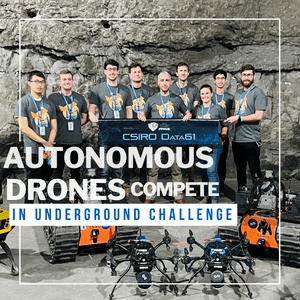
Considered the Olympics of Robotics, the DARPA SubTerranean Challenge is an autonomous robotics competition developed by the US Defence Advanced Research Project Agency (DARPA).

Read More DARPA Pushing Emesent Further Into Unreachable PlacesContinue

Emesent and Robotic Skies partner to provide local servicing for customers in the Americas
News

Emesent and Robotic Skies partner to provide local servicing for customers in the Americas

BySaad Support January 25, 2022October 7, 2024

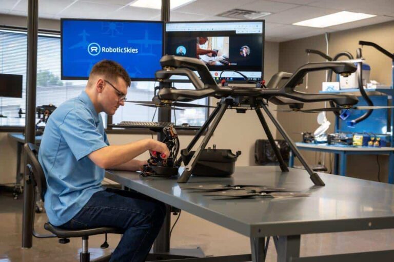
Emesent is pleased to announce a new service partnership with Robotic Skies that will mean users in the Americas get their Emesent products serviced and repaired locally.

Read More Emesent and Robotic Skies partner to provide local servicing for customers in the AmericasContinue

DARPA Competition Drives Autonomous Exploration
Webinars

DARPA Competition Drives Autonomous Exploration

BySaad Support January 19, 2022October 7, 2024

Watch this webinar to learn how placing second in the DARPA SubTerranean Challenge allowed Emesent to advance their technology’s autonomous capabilities in exploration and mapping in underground environments.
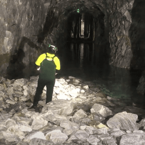
Read More DARPA Competition Drives Autonomous ExplorationContinue

Page navigation

Previous PagePrevious 1 2 3 4 5 … 12 Next PageNext
Emesent delivers high quality data capture to provide revolutionary efficiency, safety, and operational insights.
About our products
  • Hovermap
  • Aura
  • Commander
  • Book a Demo
  • Request Pricing
  • Business Plans
About our technology
  • Mapping
  • Autonomy
  • Versatility
Info & Resources
  • News & client stories
  • Customer Portal
  • Where to buy
  • Partner Portal
  • Partner with us
About our business
  • Contact us
  • About Emesent
  • Careers
  • Privacy Policy
  • Quality Policy

Copyright © 2025 Emesent. All rights reserved.

  • Products
    • Payloads
      • Hovermap
      Software
      • Aura
      • Commander
      • Cortex
      Accessories
      • 360° Image Kit
      • Backpack RTK
      • CMS Mount
      • Drone RTK
      • Hovermap LHD
      • Vehicle
 RTK
      Extensions
      • 360° Colorization
      • Automated Ground 
Control
      • Long Range Radio
      Robotics platforms
      • Boston Dynamics Spot robot
      • DJI M350 drone
      • Freefly Astro Max drone
      Ready to see how Emesent products work?​
      Get in touch
  • Solutions
    • Mining
      • Convergence Monitoring
      • Open Pit Mine Mapping
      • Stockpile Measurement
      • Stope Reconciliation
      • Underground Mine Production
      AEC
      • Construction As-built Survey
      • Infrastructure As-built Survey
      • Routine Bridge Inspection
      • Topographic Survey
      Industry use cases
      • AEC
      • Geospatial
      • Mining
      • Oil and Gas
      • Public Safety
      Third-party software workflows
      • For AEC
      • For Mining
      Ready to see how Emesent products work?​
      Get in touch
      Mining
      • Convergence Monitoring
      • Underground Mine Production
      AEC
      • Construction As-built Survey
      • Topographic Survey
      Industry use cases
      • AEC
      • Geospatial
      • Mining
      • Oil and Gas
      • Public Safety
      Ready to see how Emesent products work?​
      Get in touch
      Featured Case Study

      Leveraging 3D data for decision-making in public safety

      Read more
  • Resources
      • ALL Resources
      • Blog
      • Case studies
      • Datasets
      • Events
      • News
      • Videos
      • Webinars
      • Customer portal
      • Knowledge base
      • Partner portal
      • Client experience
      Ready to see how Emesent products work?​
      Get in touch
      Featured Content

      Hovermap Accuracy Report

      Read more

  • About
      • Our team
      • Careers
      • Contact
      Emesent’s strengths
      • Mapping
      • Autonomy
      • Versatility
      Ready to see how Emesent products work?​
      Get in touch
  • Buy
      • Book a demo
      • Resellers
      • Business plans
      • Request Pricing
      Offers
      • Hovermap 100 offer
      • Autonomy discount
      Ready to see how Emesent products work?​
      Get in touch
  • Customer Portal
  • Partner Portal

  • Español
  • 日本語
  • 中文 (简体)

Book a Demo
Search